Deprecated: WP_Translation_Controller::load_file(): Implicitly marking parameter $locale as nullable is deprecated, the explicit nullable type must be used instead in /homepages/4/d577990729/htdocs/blog/wp-includes/l10n/class-wp-translation-controller.php on line 101
Deprecated: WP_Translation_Controller::unload_file(): Implicitly marking parameter $locale as nullable is deprecated, the explicit nullable type must be used instead in /homepages/4/d577990729/htdocs/blog/wp-includes/l10n/class-wp-translation-controller.php on line 156
Deprecated: WP_Translation_Controller::unload_textdomain(): Implicitly marking parameter $locale as nullable is deprecated, the explicit nullable type must be used instead in /homepages/4/d577990729/htdocs/blog/wp-includes/l10n/class-wp-translation-controller.php on line 201
Deprecated: WP_Translation_Controller::is_textdomain_loaded(): Implicitly marking parameter $locale as nullable is deprecated, the explicit nullable type must be used instead in /homepages/4/d577990729/htdocs/blog/wp-includes/l10n/class-wp-translation-controller.php on line 243
Deprecated: WP_Translation_Controller::translate(): Implicitly marking parameter $locale as nullable is deprecated, the explicit nullable type must be used instead in /homepages/4/d577990729/htdocs/blog/wp-includes/l10n/class-wp-translation-controller.php on line 263
Deprecated: WP_Translation_Controller::translate_plural(): Implicitly marking parameter $locale as nullable is deprecated, the explicit nullable type must be used instead in /homepages/4/d577990729/htdocs/blog/wp-includes/l10n/class-wp-translation-controller.php on line 297
Deprecated: WP_Translation_Controller::locate_translation(): Implicitly marking parameter $locale as nullable is deprecated, the explicit nullable type must be used instead in /homepages/4/d577990729/htdocs/blog/wp-includes/l10n/class-wp-translation-controller.php on line 397
Deprecated: WP_Translation_Controller::get_files(): Implicitly marking parameter $locale as nullable is deprecated, the explicit nullable type must be used instead in /homepages/4/d577990729/htdocs/blog/wp-includes/l10n/class-wp-translation-controller.php on line 430
Deprecated: WP_Translation_File::create(): Implicitly marking parameter $filetype as nullable is deprecated, the explicit nullable type must be used instead in /homepages/4/d577990729/htdocs/blog/wp-includes/l10n/class-wp-translation-file.php on line 84
Deprecated: wp_getimagesize(): Implicitly marking parameter $image_info as nullable is deprecated, the explicit nullable type must be used instead in /homepages/4/d577990729/htdocs/blog/wp-includes/media.php on line 5502 General Arch Info | NABS Blog
Take part in the Utah Geological Survey’s 2021 Arch Challenge tournament as some of Utah’s well-known and lesser-known natural arches and bridges are pitted against each other for geologic superiority.
Vote each round for your favorite arches as the field of 64 geologic hopefuls is trimmed to the “Faunal Four” contenders, and ultimately Utah’s sole Arch Madness champion. The outcome of this single-elimination challenge is solely determined by your participation.
Three rounds of voting will take place March 26-28, March 29-30, and April 2-3, with the winner to be announced on April 5.
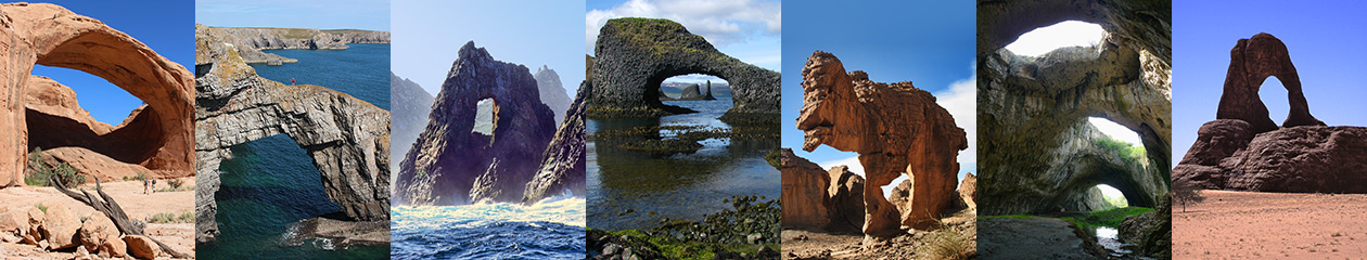
The World Arch Database, commonly known as the “WAD” in arch hunting circles, has reached a significant milestone in its 20-year history: it now contains over 10,000 natural arches and bridges! The World Arch Database is an online subscription service and can be found at Arches.StoneCanyonAdventures.com.
“Many thanks to all the arch hunters out there who have sent me mass quantities of arch data and photos over the years. I certainly could not have created the WAD without their help. And thanks to NABS for their support and cooperation in this huge endeavor,” says Tom Van Bebber, the creator of the WAD.
10,000 arches sounds like a lot of arches to get one’s head around. However, the WAD is searchable in many different ways to help users know which arches they would like to visit, study or just enjoy exploring online. They can search the obvious parameters such as by country, state or local political subdivision (County, Province, District, etc.); they can refine their search to exclude arches that are not very photogenic; or they can search for arches of a certain size (span or height, what is called the Greater Arch Dimension or “GAD” in the WAD).
Sometimes users may be looking for an arch they have heard of, but perhaps they can’t remember the exact name. In this case they can find the arch by entering a portion of the arch’s name.
As is often the case, arch hunters want to know if they have found an arch which has not been previously documented. Outside of arch hunters’ heads, the WAD is the only place where they can access the arch information needed to make a definitive determination. The photos are a big help in this regard. The WAD is now able to accommodate up to 5 photos of each arch, which can provide different perspectives of arches that may look the same or very similar otherwise. Also, a new feature of the WAD provides Internet links to videos and other additional information for a given arch which can be helpful in its identification.
A WAD search for arches by location is another useful tool. There are two ways to do this: (1) by entering keywords from the desired or suspected location (such as “Paria Canyon” or “Lake Powell”), or (2) by searching using the WAD’s new proximity search feature, whereby one can choose a point on the Earth, then search for arches within “x” degrees latitude and longitude from that point.
The WAD is not a user defined data set; users cannot add or edit the data. All arch data submitted to the WAD goes through a rigorous editing and verification process so users can have a higher degree of trust in the information.
The WAD provides other interesting and useful information about arches: type of rock, directions to the arch, land ownership and more.
Tom says “by our calculations using total land mass of the Earth, the number of arches that can be expected to exist within a given area and other criteria, we fully expect the WAD will eventually contain over 20,000 entries.”
Here are a few fun facts compiled from the WAD on the date this was written. Since the WAD is in continuous flux, this data changes constantly.
Worldwide Arch Count: 10,077
Arches with Photographic Potential Rating (PPR) of 8 or greater: 917 (8.5% of worldwide count)
Arches with Greater Arch Dimension (GAD) of 75 feet (23 meters) or more: 349 (3.2% of worldwide count)
Country with the most documented arches: United States with 8591 (79.7% of worldwide count)
US State with the most arches: Utah, with 4624 (53.8% of US count, or 42.9% of worldwide count)
US State with the second most arches: New Mexico, with 768 (8.9% of US count)
Country with the most arches outside the US: France, with over 1200 according to arch hunter Guilain Debossens
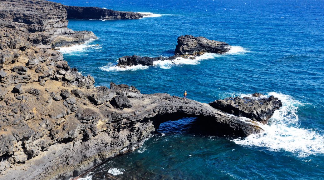
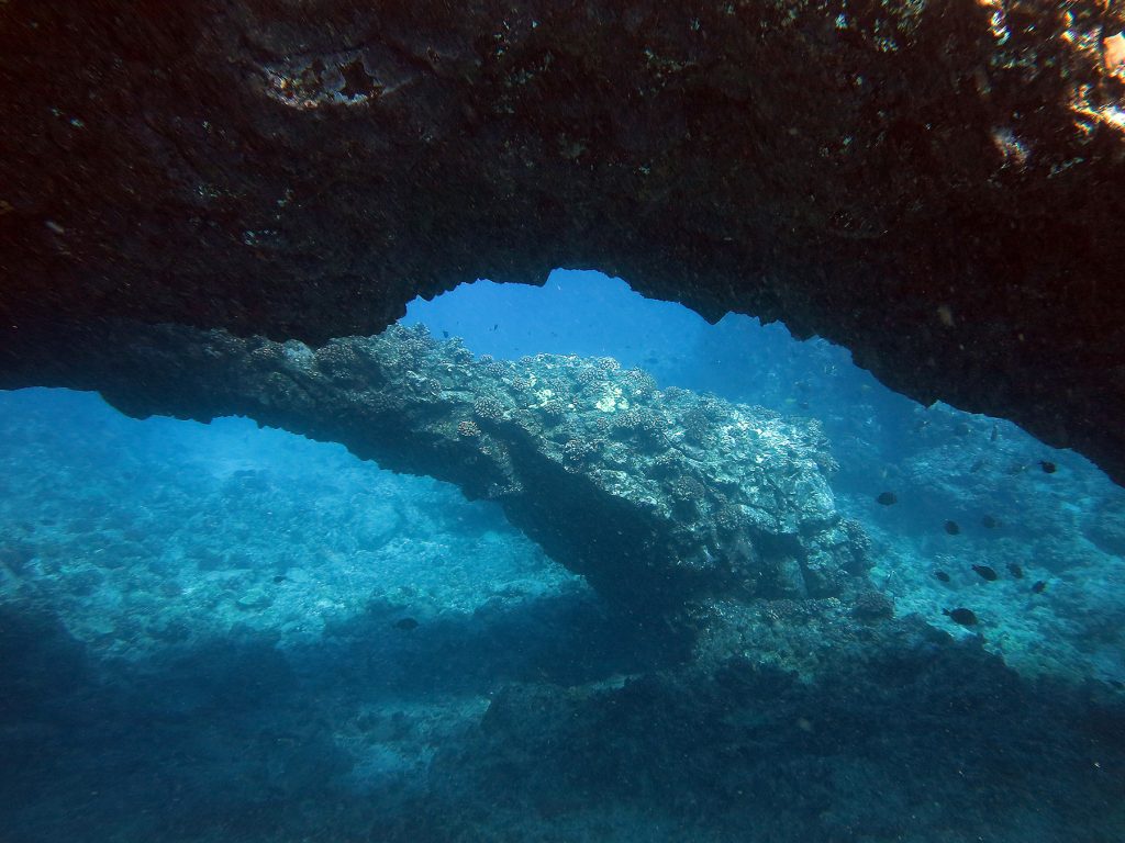
Note that the three Hawaiian arches in this article have not yet been added to the WAD, so there is more to come! All three arches are on Maui:
1. Big Kahuna Arch (photo by Cindy Bell)
2. Sea Dragon Arch (photo by Cindy Bell)
3. Golden Arches (photo by Blaze; yes, arches can be under water)
Notes from Natural Arch and Bridge Society Blog Administrator:
Please be aware that the World Arch Database is not a product of the Natural Arch and Bridge Society, although we do cooperate and share data with each other. NABS since inception in 1989 has had a goal of producing an electronic database of natural arches, but has never done so. That is because it is not easy! Tom Van Bebber, a former President of NABS, went ahead and did it on his own, hiring programmers and creating an online searchable database (the original set of data came from the late NABS member Chris Moore, who catalogued more arches than anyone else we know of). Although the WAD is a paid service, it does not make a profit and Tom could not even give it to NABS because we could not afford to run it in its current form.
The WAD shares some characteristics with all other arch catalogs ever created: they are all incomplete, have missing data, and have some incorrect data. As just one example, a recent search of the WAD turned up 12 hits, of which three did not have coordinates, three did not have any photo (and one of which had neither, which is particularly unhelpful).
However, the WAD remains the single largest and most useful arch catalog in existence, and Tom is to be congratulated on his achievement.
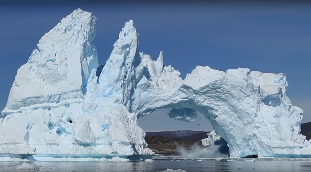
Natural arches are holes eroded in solid rock, so technically, arches made of ice don’t count. But that does not mean that arches made of ice cannot be beautiful and intriguing objects. One interesting thing about them is that they evolve much faster, although one can imagine natural arches elsewhere in the solar system (such as on outer moons or Kuiper belt objects) made of either water ice or ices of other volatiles that might last many thousands of years.
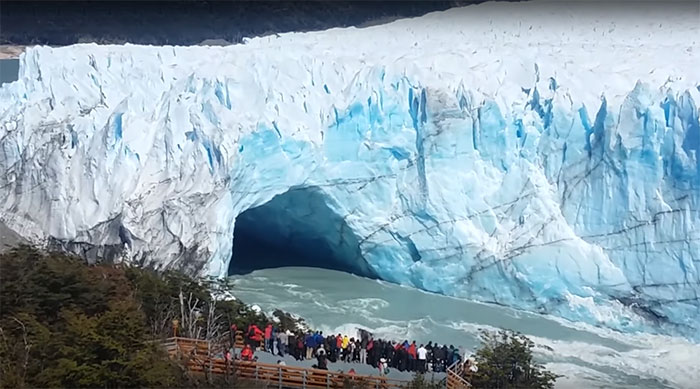
Interestingly, in Argentina there is a natural bridge made of ice that keeps re-forming and collapsing every few years! In Los Glaciares National Park (a UNESCO World Heritage site) the Perito Moreno glacier advances across a narrow neck between two parts of Lake Argentino, forming a dam. The water level rises on one side of the dam, creating pressure, and the water tunnels through the blocked section, creating an arch. Several years after it forms, usually late in the Southern Hemisphere’s summer, the arch breaks apart in a spectacular crash, and the cycle begins again. The phenomenon has nothing to do with global warming.
The most recent collapse occurred at night, when the Park was closed, on March 11, 2018, so the event was not filmed. Likewise a collapse in 2012 occurred at 3:45 a.m. and there are no pictures.
But the collapse of March 11, 2016, occurred at 10:55 a.m. and was recorded by a large number of tourists. The 4-minute video below shows the event (but misses the final collapse, which can be seen in the following 3-minute video).
This photo taken in 2017 shows the ice bridge has re-formed:
And here is a collapse in 2010 (1-minute):
Another beautiful ice arch collapse is seen in this video of an iceberg in Diskobay, Greenland, in 2015 (2-1/2 minute video):
In a December 2019 presentation to the American Geophysical Union, University of Utah researchers Riley Finnegan, Jeffrey R. Moore, and Paul R. Geimer discussed “Vibration Response of Rock Arches and Towers to Helicopter-Sourced Infrasound.”
Helicopters produce a variety of tones, the lowest of which is inaudible to the human ear, but is often the most powerful. Common civilian helicopters emit infrasound energy in the range of about 10-30 Hz, which can coincide with the natural frequencies of culturally significant rock landforms such as arches and towers. Sparse data from past studies suggest that close-proximity helicopter flight is capable of stimulating potentially damaging resonance of such landforms, but the structural response and long-term impact of this added energy remain poorly understood.
The researchers performed a series of controlled helicopter flights, using broadband seismometers and nodal geophones to measure the vibration response of five sandstone arches and six sandstone towers to infrasound emitted by a Bell 206 helicopter. They compared the measured vibration of the landforms, as well as nearby reference sites, to infrasound emitted during flight to distinguish periods of induced resonance. Alignment of the landform’s natural frequencies with those of the helicopter noise (including Doppler-shifted frequencies and overtones), the landform’s mode shape compared to the direction of infrasound propagation, and helicopter distance all contribute to the ability of helicopters to excite resonance and, in turn, the amplitude of induced vibrations.
They found that the range of landform size and geometry susceptible to helicopter-induced resonance is narrow (i.e. precise frequency alignment with the source energy is required), and that measured peak vibration amplitudes are generally below values thought to be instantaneously damaging. Nonetheless, the geographic reach of helicopters is virtually unlimited, and many well-known landforms experience regular overflights, validating concerns that sustained exposure to anthropogenic airborne energy may result in adverse structural degradation of culturally significant landforms over time.
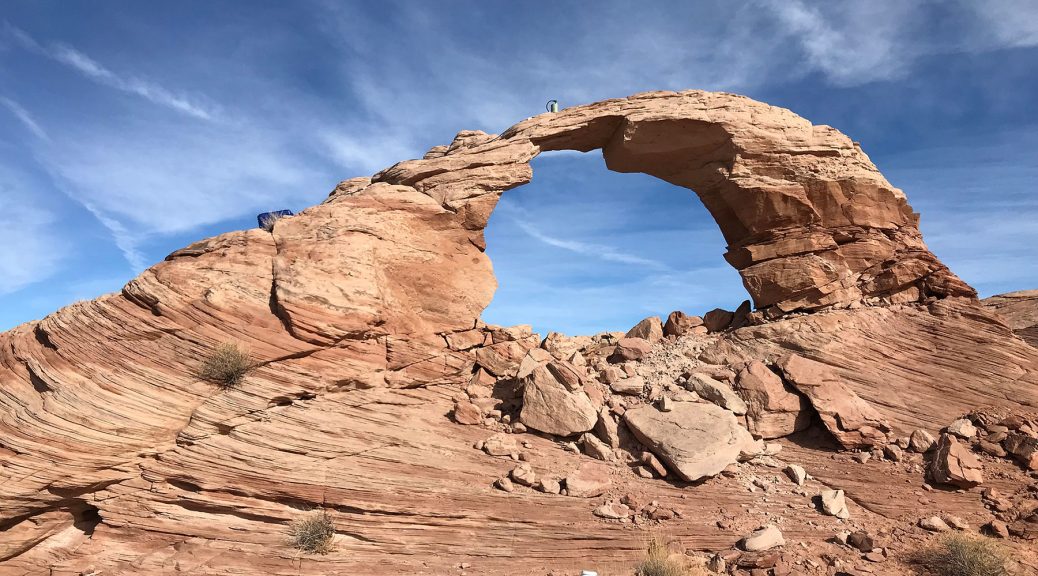
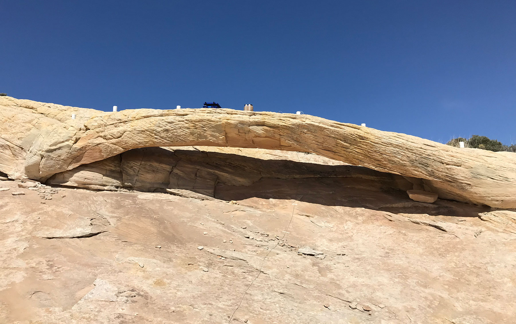
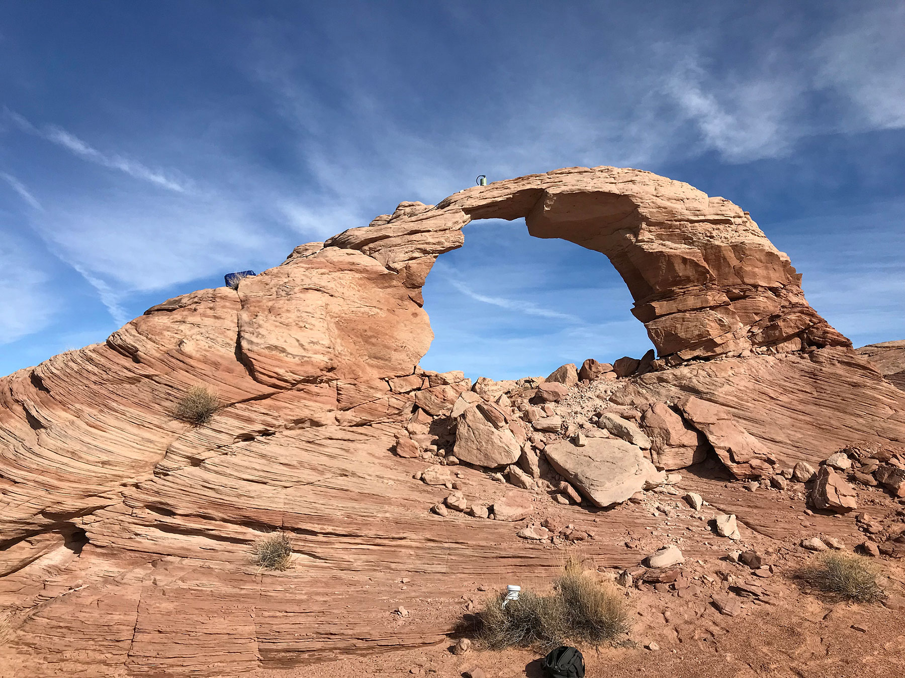
Two of the arches they studied are Squint Arch (NABSQNO 12S-528380-4277606) and Arsenic Arch (12S-540406-4217628), both in Utah. Photos of their vibration sensors on these two arches are shown below.
A video clip of a drone flyover of Arsenic Arch is below, showing the instruments on the arch.
Presenter Riley Finnegan answered the following questions:
Can you give me an overview of this research in lay terms?
Rock arches and towers vibrate back and forth all the time—just like a manmade bridge or building—though, the vibrations are so small it’s hard for a human to notice. Certain elements in an arch’s natural environment can cause the arch to vibrate faster, like wind or earthquakes. Our study tested the ways helicopter noise causes arches and towers to vibrate in ways that they don’t necessarily experience in their natural environment. We found that the size, shape, and material of the rock, along with the type, speed, distance, and direction of the helicopter contribute to the vibration levels of each geologic feature. We found the range of rock arches and towers susceptible to strong vibrations from exposure to inaudible helicopter sound is narrow, and the vibration levels measured are generally below values considered immediately damaging. Nonetheless, helicopters can fly nearly anywhere, and many arches and towers experience regular helicopter flyovers, validating concerns that inaudible helicopter sound may cause damage to culturally significant rock features over time.
What is new about your findings compared to what is already known in this field? How do your results compare to what is already known about this area of research?
We borrow techniques from a variety of fields, including seismology and structural engineering. Engineers have studied the vibrations of manmade structures for decades, and we use the same methods to understand the resonant frequencies of landforms like arches and towers. Few other groups study the resonant frequencies of arches and towers, so the natural frequencies of many of the features we’ve studied are shared here for the first time. Similarly, few past studies have recorded the vibrational response of natural landforms to helicopter noise, so we share those results here as well. In particular, we explore factors like the landform’s geometry and material properties, and helicopter speed, direction, and distance, and how they relate to the vibration of the landform.
Did you come across anything surprising or unusual in the course of your study?
The lowest frequency of noise emitted by the helicopter is the most powerful, so we predict that the strongest vibrational response of the arches and towers to helicopter noise would be from exposure to noise in that lower frequency range. However, where a landform’s natural frequencies didn’t fall in that lower frequency range of helicopter sound, but coincided with less powerful but higher overtones of helicopter noise, we saw a strong vibrational response.
We were also surprised that the propagation direction of the helicopter noise is extremely important in coupling with the mode shape of the landform exposed to the noise. If the noise is emitted in a horizontal direction, a landform that tends to vibrate horizontally will respond with greater vibrations than a landform that tends to vibrate vertically. In hindsight, this seems obvious, but we didn’t confirm this until our data showed an arch inclined towards vertical motion vibrating at the same velocities when the helicopter was thousands of meters away, banking with the noise directed downwards, as when the helicopter was only a few hundred meters away with the noise directed horizontally. This really showed to us that landform geometry and noise direction are important in describing the impact helicopter noise has on these landforms—blanket statements like, “If a helicopter is x meters away, then a feature will vibrate x meters per second” do not fully capture the nuances of landform vibration response to energy sources.
Are the sounds emitted by helicopters unique, or could other sources of sound potentially cause damage to these rock features?
We are also investigating the impact that trains, road noise, and earthquakes can have on rock arches and towers, though those energy sources aren’t featured here.
What are the implications of this research, and why should people care?
I think too often we consider the desert landscape as still, and without much life. Our vibration measurements remind us that the rocks around us are moving all the time, and this particular study helps to remind us that we might be impacting the natural evolution of the landscape in ways we don’t even consider. I think people would generally oppose taking a jackhammer to Delicate Arch, but not everyone has the repercussions of helicopter flight near these culturally significant landforms at the top of their list of environmental concerns. Arches and towers are iconic in the desert southwest so it’s important that we work towards preserving these important features.
Have these results (or similar results by yourself or colleagues) been previously publicized by your institution or reported on by the press? If so, where and when?
None of our past-published works have focused on helicopter-induced resonance of natural landforms, but “Anthropogenic sources stimulate resonance of a natural rock bridge” (Jeffrey R. Moore, et al., 2016) received publicity by the University of Utah and other media outlets. That paper highlighted how an artificial reservoir, Lake Powell, excited resonance in Rainbow Bridge, one of the world’s largest natural bridges.
[Jeffrey Moore also published an article in the Fall 2015 issue of SPAN, the newsletter of the Natural Arch and Bridge Society, on “Monitoring the Structural Dynamics of Natural Arches” and reports on that work can be found at https://geohazards.earth.utah.edu/arch.html.]
How did this work come about?
This work came about by the Native American Consultation Committee (NACC, formed in the 1990s for indigenous groups to provide official stances on the regulation and management decisions for Rainbow Bridge National Monument) raising the question of how helicopter tours were impacting the structural integrity of Rainbow Bridge. The NACC is comprised of representatives from the Hopi, Kaibab Paiute, Navajo, San Juan Southern Paiute, Ute Mountain Ute, and Zuni tribes, all of which share a historical connection with Rainbow Bridge. While Rainbow Bridge resonates at such low frequencies that it is unlikely to be susceptible to damage from helicopter noise, the question opened up further exploration with smaller arches and towers that could resonate at the frequencies emitted by helicopters.
No, the Natural Arch and Bridge Society does not make money from arches.
But some governments do.
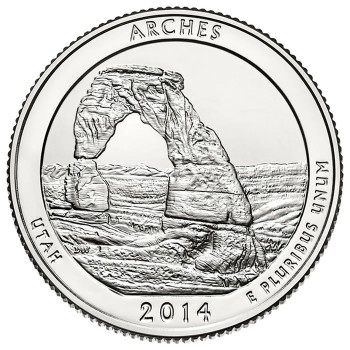
The United States Mint released an Arches National Park quarter in 2014 as part of its America the Beautiful Quarters Program, featuring Delicate Arch. You can buy a 100-coin bag of these from the U. S. Mint ($25 face value) but it will set you back $40 with shipping. [UPDATE 2016: Not any more, but you can get a pack of 3 for $9.95 + $4.95 shipping.]
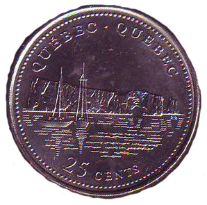
NABS member Daniel Putelat has the following coins in his collection. Quebec released a coin featuring Le Rocher Percé:
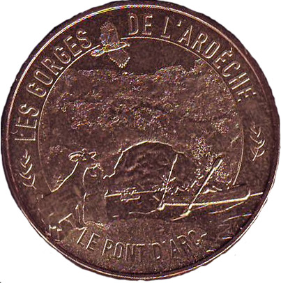
He also has in his collection this 2015 Monnaie de Paris (Money of Paris) featuring Pont d’Arc:
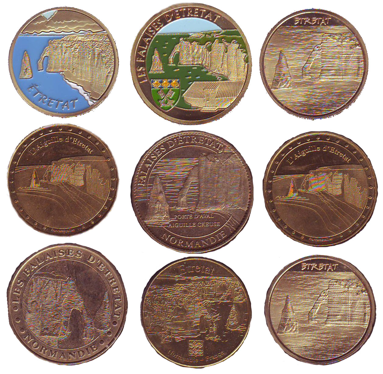
Daniel also has in his collection these Monnaie de Paris featuring Etretat:
Paper bank notes have also been produced. Below is Pigeon Rock in Lebanon.