Libya: Akakus Plateau
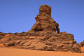
The Akakus Plateau is in the southwestern part of Libya. Access to this part of the Sahara Desert is only possible by strong four wheel drive vehicles with experienced drivers. The rock formations in the area look similar to southern Utah's canyon country, but vegetation is almost completely missing and the canyons are broader and more sandy. The Akakus mountains are well known for prehistoric pictographs and pictograms with an age of 2000 - 11000 years. Geographically and geologically, the Akakus is an extension of the Tadrart region of Algeria but the border is closed between those two countries. The jumping off point for travel to Akakus is Al Uwaynat, a small desert town on the main road from Sabha to Ghat. Al Uwaynat is about 270 miles south west of Sabha (about a 4 hour drive) and about 90 miles from Ghat. The nearest airport is at Sabha while the airport at Ghat is closed for modernization (as of April 2008). Our correspondent Ray Millar was pleased with his travel arrangements through www.waradd.com.
For larger photos (and GPS locations) click on the thumbnail images on the right.
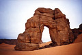
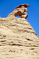
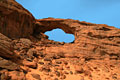
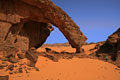
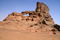
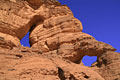
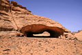
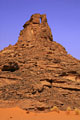
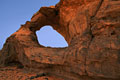
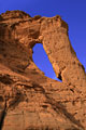
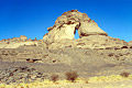
| FORZHAGA ARCH is the most spectacular in the Akakus Plateau. The arch is located in the southwest corner of
Libya near the border with Algeria, about 20 miles east of the Tuareg Village
of Ghat, near the junction of Oued Anchal and Oued Tanchalt
("oued" is the local name for "wash"). There are no roads or trails to the arch, and hiring a guide is required to visit the area. For scale, note the two figures under and just behind the arch. Ray Millar measured the span at 104 feet and the height at 143 feet. Photo by Verene Jordi. |
|
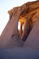
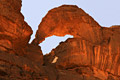
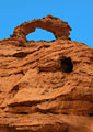
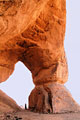
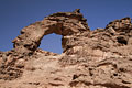
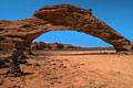
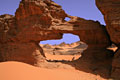
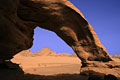
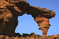
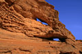
| FEZZI JAREN ARCH is another well-known arch of the Akakus, appearing on local postcards. It has three openings and is a fine example of a pillar natural arch. The largest opening has a span of 36 feet and a height of 61 feet. Photo by Peter Felix Schaefer. |
|
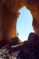
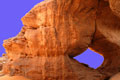
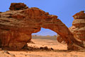
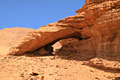
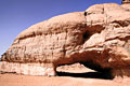
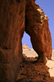
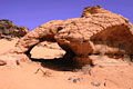
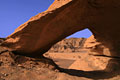
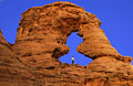
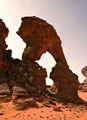
| UNNAMED ARCH on the Akakus Plateau of Libya at GPS location 32R 0650417 2743949. It is easy to climb into the opening. The span was measured at 37 feet and the height at 62 feet. Photos by Peter Felix Schaefer and Dagmar Schaefer. |
 |
|
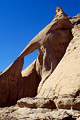
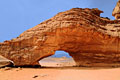
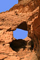
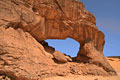
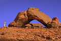
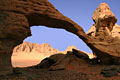
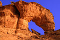
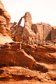
| UNNAMED ARCH about 100 meters to the west of the previous arch. The span was measured at 15 feet and the height is estimated at 33 feet. Photo by Peter Felix Schaefer. |
|
| UNNAMED ARCH. If you follow the oued past the previous arches to its end, you will reach an interesting canyon with nice narrows. Follow it for maybe half a mile and you'll come to a deep pothole with a lot of water in it (a rare find in the Sahara). On the way back, keep your eyes open for this small but nice arch on the left rim high above you. Photo by Peter Felix Schaefer. |
|
| UNNAMED ARCH high on the canyon wall near the main route through the Akakus. Photo by Ray Millar. A beautiful photo of this arch from the other side was published in a French calendar about the Sahara Desert. |
|
| UNNAMED ARCH, Akakus Plateau, Libya, at GPS location 32R 652294E 2803275N. It has a measured span of 23 feet and height of 12 feet. Photo and measurements by Ray Millar. |
|
| AWES ARCH, Akakus Plateau, Libya, at GPS location 32R 655722E 2803265N. It has a measured span of 30 feet and height of 10 feet. Photo and measurements by Ray Millar. |
|
| UNNAMED ARCH, Akakus Plateau, Libya, at GPS location 32R 657210E 2799807N. It has a measured span of 25 feet and height of 10 feet. Photo and measurements by Ray Millar. |
|
| UNNAMED ARCH, Akakus Plateau, Libya, at GPS location 32R 656455E 2799961N. It has an estimated span of 12 feet and height of 7 feet. Photo by Ray Millar. |
|
| UNNAMED ARCH, Akakus Plateau, Libya, at GPS location 32R 657012E 2800349N. It has a measured span of 44 feet and height of 20 feet. Photo and measurements by Ray Millar. |
|
| UNNAMED ARCH, Akakus Plateau, Libya, at GPS location 32R 6657041E 2800378N. It has a measured span of 14 feet and height of 21 feet. Photo and measurements by Ray Millar. |
|
| UNNAMED ARCH, Akakus Plateau, Libya, at GPS location 32R 668141E 2756280N. It has a measured span of 41 feet and height of 17 feet. Notice the person to the right of the arch for scale. Photo and measurements by Ray Millar. |
|
| TINE LOPO, Akakus Plateau, Libya, at GPS location 32R 666183E 2756975N. It has a measured span of 40 feet and height of 46 feet. Photo and measurements by Ray Millar. |
|
| UNNAMED ARCH, Akakus Plateau, Libya, at GPS location 32R 666256E 2757353N. It has a measured span of 27 feet and height of 8 feet. Photo and measurements by Ray Millar. |
|
| UNNAMED ARCH, Akakus Plateau, Libya, at GPS location 32R 659920E 2752526N. It has a measured span of 36 feet and height of 21 feet. Photo and measurements by Ray Millar. |
|
| UNNAMED ARCH, Akakus Plateau, Libya, at GPS location 32R 667129E 2746816N. It has an estimated span of 30 feet and height of 18 feet. Photo by Ray Millar. |
|
| UNNAMED ARCH, Akakus Plateau, Libya, at GPS location 32R 666076E 2744331N. It has an estimated span of 36 feet and height of 36 feet. Photo by Ray Millar. |
|
| UNNAMED ARCH, Akakus Plateau, Libya, at GPS location 32R 666076E 2744331N. 32R 668435E 2736410N. It has an estimated span of 27 feet and a measured height of 9 feet. Photo and measurement by Ray Millar. |
|
| UNNAMED ARCH, Akakus Plateau, Libya, at GPS location 32R 665764E 2731703N. It has a measured span of 27 feet and a height of 12 feet. Photo and measurements by Ray Millar. |
|
| UNNAMED ARCHES, Akakus Plateau, Libya, at GPS location 32R 662578E 2735033N. Note the person in the upper arch for scale (both openings are accessible). Photo by Ray Millar. |
|
| UNNAMED ARCH, Akakus Plateau, Libya, at GPS location 32R 660660E 2735263N. Note the person to the lower right for scale. The arch has a measured span of 152 feet and a height of 98 feet but is only separated from the cliff behind it by 3 or 4 feet. Photo and measurements by Ray Millar. |
|
| INFUDHA ROCK ARCH, Akakus Plateau, Libya, at GPS location 32R 669327E 2731848N. It has a measured span of 35 feet and a height of 11 feet. The 4WD vehicles drive through the opening. Photo and measurements by Ray Millar. |
|
| UNNAMED ARCH, Akakus Plateau, Libya. This arch is located close to the previous arch. It has a measured span of 6 feet and a height of 12 feet. Photo and measurements by Ray Millar. |
|
| UNNAMED ARCH, Akakus Plateau, Libya, at GPS location 32R 670740E 2730648N. It has a measured span of 21 feet and a height of 4 feet. Photo and measurements by Ray Millar. |
|
| UNNAMED ARCH, Akakus Plateau, Libya, at GPS location 32R 669701E 2729570N. It has a measured span of 37 feet and a height of 17 feet. Photo and measurements by Ray Millar. |
|
| UNNAMED ARCH, Akakus Plateau, Libya, at GPS location 32R 669605E 2729820N. It has an extimated span of 7 feet and a height of 30 feet. Photo by Ray Millar. |
|
| UNNAMED ARCH, Akakus Plateau, Libya, at GPS location 32R 669696E 2730004N. It has a measured span of 13 feet and a height of 7 feet. Photo and measurements by Ray Millar. |
|
| UNNAMED ARCH, Akakus Plateau, Libya, at GPS location 32R 670742E 2729604N. It has an estimated span of 5 feet and a height of 15 feet. Photo by Ray Millar. |
|
| UNNAMED ARCH, Akakus Plateau, Libya, at GPS location 32R 671664E 2727691N. It has a measured span of 21 feet and a height of 13 feet. Photo and measurements by Ray Millar. |
|
| UNNAMED ARCH, Akakus Plateau, Libya, at GPS location 32R 671693E 2727652N. It has a measured span of 23 feet and a height of 13 feet. Photo and measurements by Ray Millar. |
|
| UNNAMED ARCH, Akakus Plateau, Libya, at GPS location 32R 671693E 2727652N. It has a measured span of 23 feet and a height of 13 feet. Photo and measurements by Ray Millar. |
|
| UNNAMED ARCH, Akakus Plateau, Libya, at GPS location 32R 672333E 2727001N. It has a measured span of 18 feet and a height of 17 feet. Photo and measurements by Ray Millar. |
|
| UNNAMED ARCH, Akakus Plateau, Libya, at GPS location 32R 672595E 2726228N. It has a measured span of 16 feet and a height of 14 feet. Photo and measurements by Ray Millar. |
|
| UNNAMED ARCH, Akakus Plateau, Libya, at GPS location 32R 674408E 2725668N. It has an estimated span of 26 feet and a height of 26 feet. Photo by Ray Millar. |
|
| UNNAMED ARCH, Akakus Plateau, Libya, at GPS location 32R 675303E 2725512N. It has a measured span of 27 feet and a height of 18 feet. Photo and measurements by Ray Millar. |
|
| UNNAMED ARCH, Akakus Plateau, Libya, at GPS location 32R 675975E 2725506N. It has an estimated span of 10 feet and a height of 25 feet. Photo by Ray Millar. |
|
| UNNAMED ARCHES, Akakus Plateau, Libya, at GPS location 32R 675598E 2725771N. The upper arch has a span of 8 feet and the lower arch has a span of 10 feet. Photo and measurements by Ray Millar. |
|
| UNNAMED ARCH, Akakus Plateau, Libya, at GPS location 32R 670541E 2738743N. It has a measured span of 13 feet and a height of 20 feet. Photo and measurements by Ray Millar. |
|
| UNNAMED ARCH, Akakus Plateau, Libya, located southwest of this arch. It has an estimated span of 30 feet and a height of 60 feet. Photo by Ray Millar. |
|
Go to next Gallery feature
- La Fenetre de l'Isalo, Madagascar
Return to International Gallery