NABSQNO 12S-686282-4333130
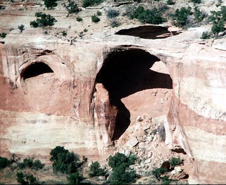
Finger Arch, Mesa County, Colorado
Photo by David Brandt-Erichsen
Example Cave Natural Arch
NABSQNO 12S-686282-4333130. Finger Arch is an old cave natural arch. It might be considered a pothole natural arch by some, but the shape of the cavity behind the arch is more likely a cave remnant than a pothole. Note the lip or rim that surrounds the upper, horizontal entrance. This is very suggestive of roof collapse and is very unlikely to have been caused by a pothole. Also note the cave to the left of the arch. Finger Arch probably looked much like this small cave before it grew to the point where its roof became too thin to support its own weight. It has eroded through Entrada sandstone.Finger Arch is also known as West Rim Arch. It is located above Rattlesnake Canyon in a wilderness area west of Colorado National Monument in Mesa County, Colorado. To access the arch contact the BLM office in Grand Junction for information and directions.
Vreeland listed Finger Arch in his catalog as 18-15. It has a span of about 70 feet.
| Topo Map | Google Map | State Index |
Other Cave Natural Arch examples:
| Wild Horse Arch | Sam Bass Arch | Egg Shell Arch | Hole in the Bridge Arch | West Rim Arch | unnamed arch |