|
|

|
Natural Arches of Tassili National Park |
Index Page 22 - Jabbaren Area - Map 11 |
|
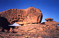
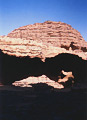
ALG-61, Long Slit Arch, Jabbaren Area. 7.5 meter span (measured). GPS 32R 573328 2706886. This
arch is located at the Jabbaren site on the lower part of the cairned loop trail. You can find
the arch where the trail skirts the canyon valley rim. Jabbaren site can be reached from the
Tin-Kani site via Tin-Essou (about 6 hours hiking) or from Djanet-Ifni and the 4WD road to the
bottom of the Tassili cliff. From there it will take 4 hours to climb to the Jabbaren site via
Akba Aroum (Aroum Pass). Jabbaren site is located on the lower level of the plateau ledge. There
are few natural arches in the area but an abundance of great rock art. Most of the people who
visit the Jabbaren site do not use donkney but hike there and back on the same day. If this is
your choice, be ready for a very long and strenuous day. To fully enjoy the site, the author
recommends a minimum two day trip. Jabbaren means "giant" in the Tamahaq dialect.
|
|
|
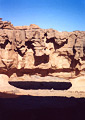
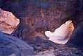
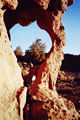
ALG-62, Shepherd's Fresco Arch, Jabbaren Area. 6.2 meter span
(measured). GPS 32R 570402 2706625. From ALG-61 (Long Slit Arch), continue on the cairned loop
trail northwest, leaving the rim trail and entering into the maze (rock blocks). Walk inside the
little maze for 5 minutes to the oval opening. The trail goes by the arch. As the name suggests,
there is a beautiful fresco on the side of the opening. The rock art is estimated at 8,000 years
old. The shepherd people living there in the past were perhaps fascinated by rock opening
symbolism. If you like both arches and rock art, you will have a great moment here.
|
|
|
ALG-64, unnamed arch 60, Jabbaren Area. 2 meter span (estimated). This small arch is located on
the side of the trail farther up trail from ALG-62 (Shepherd's Fresco Arch). It is located half
way between ALG-62 and a little Tamarisk tree into the little maze.
|
|
|
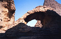
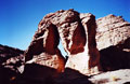
ALG-63, Tallit Arch, Jabbaren Area. 4.1 meter span by 2.3 meter
height (measured). From ALG-64, leave the trail and explore the labyrinthe area (west) to find
this arch. Tallit means "full moon" in the Tamahaq dialect.
|
|
|
ALG-65, unnamed arch 61, Jabbaren Area. 2.5 meter span (estimated). Explore the area around
ALG-63 (Tallit Arch) to find this one.
|
|
|
ALG-511, Two Tarout Arch, Jabbaren Area. 2 meter height (estimated). From the official campsite
of Jabarren, walk 400 meters north to the beginning of Jabbaren Oued. Follow the drainage down
canyon to two
cypress trees, called
"Tarout" in Tamahaq dialect. The arch is located futher down canyon to the right. The
two Tarout are visible through the arch, hence the name.
|
|
|
ALG-512, Slit Arch, Jabbaren Area. 2 meter height (estimated). From ALG-511 (Two Tarout Arch),
walk down canyon for 600 meters and pass on the way four more "Tarout" (cypress
trees). Pass the fourth cypress tree and walk up the little drainage carved in the sandstone for
100 meters to a dry pothole. The arch is located above the photole to the right. If you walk
futher down canyon past the fourth cypress tree, you will arrive at a huge pile of fallen blocks
before the wash drops into a deep gorge.
|
|
|
|
|
|
Index Page
|
|
Next Arch ALG-2
|
|