|
|

|
Natural Arches of Tassili National Park |
Index Page 15 - Unnamed Reef One - Map 1 |
|
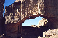
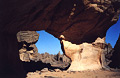
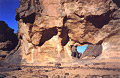
ALG-147, Hole in the Ceiling Arch, Unnamed Reef One. 14 meter span
(measured), 9 meter height (estimated). GPS 32R 567990 2729770. This arch is located along the
trail from Tin-Aboteka to Tamrit. From the vivouac area of Tin-Aboteka, walk northwest up
through rock masses and enshrined sand dunes for 200 meters to a flat area (see
ALG-162, Perched Arch). Cross the flat following the trail (check with
your guide) for 800 meters or so and leave the Tin-Aboteka reef by going left. Now you walk
along the pinnacles of Unnamed Reef One for approximately 2.5 kilometers northwest. Then enter
the reef (west) following a oued which takes you to a small saddle. Walk up the saddle to the
arch, located on the side of the trail on the right. It is located about 35 minutes of hiking
from the bivouac area of Tin-Aboteka.
|
|
|
ALG-148, Bird Table Arch, Unnamed Reef One. 3.5 meter span
(estimated). This arch is visible 100 meters from Hole in the Ceiling Arch (ALG-147), up on the
reef to the east.
|
|
|
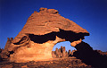
ALG-149, Slender Arch, Unnamed Reef One. 6.4 meter span
(measured). From the saddle just beyond Hole in the Ceiling Arch (ALG-147), walk southeast about
100 meters to this beautiful span.
|
|
|
ALG-150, Femur Arch, Unnamed Reef One. 1 meter span (estimated). From Slender Arch (ALG-149),
cross the reef straight ahead (east) for about 400 meters to this small arch, which is very hard
to find.
|
|
|
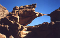
ALG-152, Araleg Arch, Unnamed Reef One. 4.3 meter span by 2.9 meter height (measured). GPS 32R
569576 2731073. Find this arch in Unnamed Reef One about 1.5 kilometers east of Hole in the
Ceiling Arch (ALG-147). Araleg means "raven" in the Tamahaq dialect.
|
|
|
ALG-151, unnamed arch 33, Unnamed Reef One. 1.5 meter span (estimated). This arch is located
relatively close to Araleg Arch (ALG-152).
|
|
|
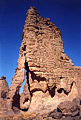
ALG-153, Propped Arch, Unnamed Reef One. 3 meter height (estimated). Somewhere in a wide area
around Araleg Arch (ALG-152) but unfortunately my notes are incomplete on this one. Propped Arch
is an example of a propped natural arch.
|
|
|
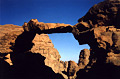
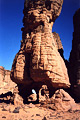
ALG-146, Tripod Arch, unnamed area. This unusual arch is located
on the trail between Tin-Aboteka and Tamrit. From Hole in the Ceiling Arch (ALG-147), continue
up the trail (west) to the top of the saddle. Proceed on the trail across the reef for 15
minutes or so to a second saddle which leads you to the higher plateau. From there you leave the
Sefar Sandstone Formation and enter the Tamrit Sandstone Formation (see
Introduction). Hike for 25 minutes past the second saddle on a
magnificent landscape of sand dune and rocks before passing this amazing arch on the side of the
trail on the right. You can't miss this arch (in both senses -- it is easy to spot, and you must
see this wonderful arch). From this arch it takes about two hours to reach the Tamrit site
(Sonatrach camp).
|
|
|
|
|
|
Index Page
|
|
Next Arch ALG-145
|
|