NABSQNO 13S-323394-4169873
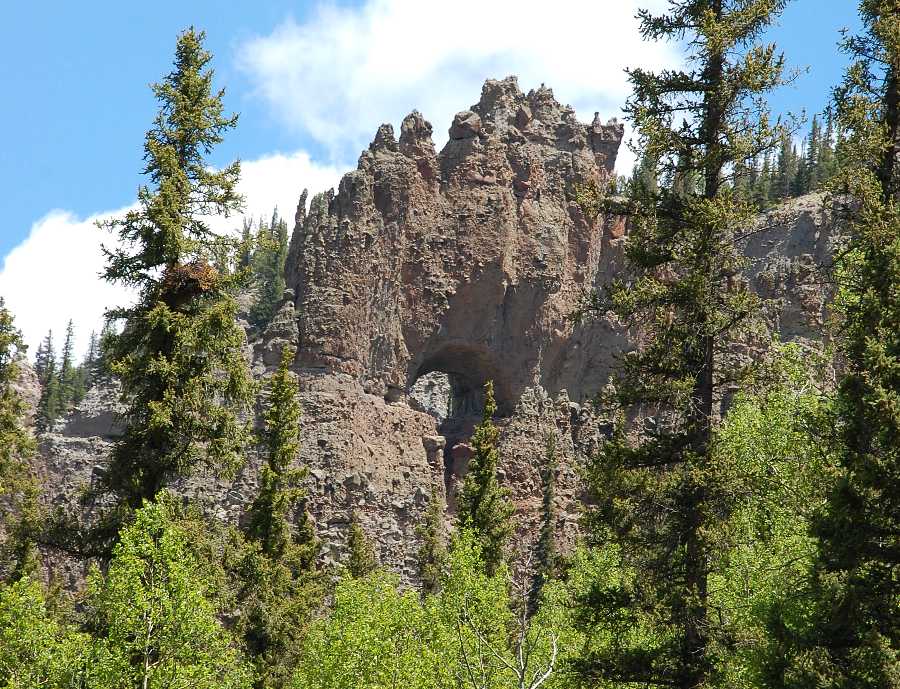
Rhoda's Arch, Mineral County, Colorado
Photo by Jay Wilbur
NABSQNO 13S-323394-4169873. Rhoda's Arch is a shelter natural arch eroded through a narrow ridge of trachyte. It is located in the Rio Grande National Forest above the eastern bank of Red Mountain Creek (once named South River) about 15 miles southwest of Creede, Colorado. Statements that this arch was located in the Wheeler Geologic Area (also in Mineral County) and collapsed several years ago are not correct.
The only practical access to the arch, even to a viewpoint of the arch, is by crossing private land. Both of the photos on this page were taken from different points on that private land. Special permission of the landowner was obtained to acquire these photos. The landowner normally does not grant such permission.
Rhoda's Arch gets its name from Franklin Rhoda, a topographer who accompanied the 1875 Hayden expedition to explore Colorado for the US Government. Rhoda is also renowned in mountain climbing circles for having been the first to scale several Colorado peaks. His account of his visit to this arch is quoted below from page 312 of Ninth Annual Report of the United States Geological and Geographical Survey of the Territories, Colorado and Parts of Adjacent Territories: Being a Report of Progress of the Exploration for the Year 1875, F. V. Hayden, Government Printing Office, 1877.
"Several of the walls had large and very regular arches worn through them. From some views these arches appear as perfect in form and proportion as if built by the hand of a mason. I succeeded by climbing along the wall on a very narrow ledge to get into one of these, and found it remarkably perfect on a near view also. It was about 50 feet span, with an altitude of 20 to 30 feet, the base being somewhat uneven, and the wall about 40 feet thick. This would seem to be a pretty large arch, but looking at it from the outside it is dwarfed into insignificance by the size of the massive walls through which it forms a gateway. This arch was situated about 100 feet above the foot of the wall, and about 200 below the summit. Looking out of it on either side you could see an inclosure formed by the walls on the sides."
There are some quite regular, arch-shaped caves in the many ridges around the one containing Rhoda's Arch, however none go completely through. They are all caves rather than true natural arches. Rhoda's Arch appears to be the only true natural arch in this area.
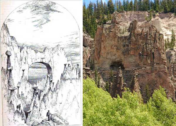
Drawing by Frederic M. Endlich, 1875, public domain. Photo by Jay Wilbur
A drawing of Rhoda's Arch that was published in the Hayden Report has become well-known. This drawing, by Frederic Endlich, is compared above to a photo taken from a similar vantage point north of the arch. (The photo shown at the top of this page was taken from south of the arch.) It is obvious that the artist took license to idealize some aspects of the arch. Rhoda's description of the arch, quoted above, is a more accurate depiction of its size in relationship to the ridge it pierces. As might be expected from a topographer, the dimensions of the arch Rhoda provided are also quite accurate. It is also interesting to note that many of the hoodoos in front of the arch have not changed in any significant way during the 134 years that separate the photo from the drawing. This suggests that the arch has also not experienced much erosion over the same period.
| Topo Map | Google Map | Return to State Index |