Canada Portfolio
Click on thumbnail image for larger image with the same information
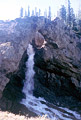
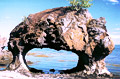
| ALBERTA: Red Deer Natural Bridge is a waterfall natural bridge (with a waterfall flowing through it) located in Banff National Park. The shortest hike to it is 14.7 miles one way so it is usually visited by backpacking. For this a backcountry camping permit is required (there are three campsites between the parking area and the bridge). There is an elevation gain of 2600 feet and two fords are required to reach the bridge. The natural bridge is situated in the valley between Oyster Peak and Mt. Douglas, on a tributary stream to the Red Deer River. The span is estimated at 11 feet and the height at 18 feet. Directions can be found in The Canadian Rockies Trail Guide by Brian Patton and Bart Robinson. Photo by Larry Fogleman. NABSQNO 11U-569300-5709630. |
|
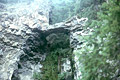
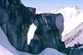
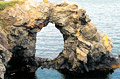
| ALBERTA: This unnamed natural arch is located in Jasper National Park and can be seen high on the ridge to the east of Maligne Lake Road. From the north terminus of Maligne Lake Road at Provincial Highway 16, head south on Maligne Lake Road for 18.4 miles to a pullout for viewing the arch. The arch is visible for quite some distance along the road. It has an estimated span of 45 feet. Photo by Larry Fogleman. |
|
| BRITISH COLUMBIA: Clearwater Natural Bridge has an estimated span of 40 feet and is located in the Clearwater District of the Kamloops Region of the British Columbia Provincial Forest, about 5 miles north of Clearwater. A one-mile hiking trail in the Clearwater River Trail system goes to a view of the bridge. Photo by Larry Fogleman. |
|
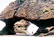
| BRITISH COLUMBIA: This natural bridge has an estimated span of 18 feet and is located in the Clearwater District of the Kamloops Region of the British Columbia Provincial Forest, about 16 miles west of Clearwater via a good gravel road. A short trail goes to the bridge. Photo by Larry Fogleman. |
|
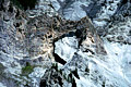
| BRITISH COLUMBIA: This unnamed arch is located in the Bugaboo Alpine Recreation Area in Bugaboo Mountain Provincial Park. WARNING: It is not recommended to try to reach this arch without a guide. Reaching the arch requires crossing a dangerous glacier where loss of life has occurred. Photo by Larry Fogleman. |
|
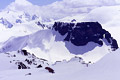
| BRITISH COLUMBIA: The Teacup Handle can be seen on the right side of this photo of The Table in Garibaldi Provincial Park, British Columbia. The height of the opening is estimated at 80 feet. The flat-topped mountain was formed during the last ice age when lava bubbled up into the overlying ice, forming a mold for the magma which subsequently solidified. Today this mountain is almost impossible to climb because sections have collapsed, creating steep and exceptionally rotten rock walls on all sides. The Teacup Handle has reportedly never been climbed. Photo taken from the summit of Mt. Price by Marek Labecki, courtesy of www.bivouac.com, the Canadian Mountain Encyclopedia. |
|
| BRITISH COLUMBIA: This large, unnamed natural arch is located in the McBride/Goat River District of the Prince George Region of the British Columbia Provincial Forest, near Dunster. A four-mile trail in poor condition leads to a view of the arch. Photo by Larry Fogleman. |
|
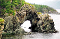
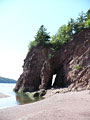
| NEW BRUNSWICK: Arch Rock. This small but attractive arch is at Inch Arran Park in Dalhousie near to the Quebec border. According to legend, the profile of a Mi'gmag Indian Chief is preserved in the arch as he is watching over his people at the Eel River Bar First Nation.
The arch has a span of 13 feet and a height of 7 feet. Photo by Ray Millar. NABSQNO 19U 697222 5326051. |
|
| NEW BRUNSWICK: Hole in the Wall. This is the main attraction of Hole in the Wall Provincial Park on Grand Manan Island. The island is in The Bay of Fundy southwest of Saint John and can be reached by ferry from Blacks Harbour. The park is less than a mile from the ferry terminal.
The arch has an estimated span of 14 feet and estimated height of 19 feet. Photo by Ray Millar. NABSQNO 19T 678104 4960686. |
|
| NEW BRUNSWICK: Lovers' Arch.
Probably the best known arch in the Maritimes, Lovers' Arch is located at Hopewell Rocks Provincial Park. The park is on Shepody Bay, an arm of The Bay of Fundy. The park is 36 km (22.5 miles) southeast of Moncton in southeast New Brunswick. Although the arch can be viewed at any time, access is only possible two hours either side of low tide.
The arch has a span of 30 feet and a height of about 18 feet. Photo by Ray Millar. NABSQNO 20T 377840 5075355. |
|
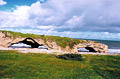
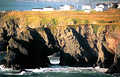
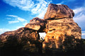
| NEWFOUNDLAND: The Arches. These three spectacular arches are the main attraction of The Arches Provincial Park (notice the person on the left for scale). There used to be four arches but one has collapsed. The park is located between Parson's Pond and Portland Creek, about half way up the west side of the Northern Peninsula. All three arches have a height of 15 feet. The south arch has a span of 55 feet (the south arch also has a 15-foot opening in the side), the middle arch has a span of 29 feet, and the north arch has a span of 38 feet. Photo by Ray Millar. NABSQNO 21U 452481 5551552. |
|
NEWFOUNDLAND: The Dungeons. In 1497 John Cabot sailed from Bristol, England on a transatlantic voyage. He sighted land at Cape Bonavista. Not far from where he landed are these two large arches. The Cape is on the Bonavista Peninsula to the north of St. Johns. Photo by Ray Millar. NABSQNO 22U 346534 5392528.
|
|
| NEWFOUNDLAND: Langdon's Cove Arch.
This arch is situated in scenic Green Bay, north of Springdale. It can be viewed by taking the Oceanview Hiking Trail, located between Jackson's Cove and Langdon Cove. The trail, which has boardwalk in parts, has a number of wooden viewing platforms. The second platform is on top of the arch although it can't be seen from there. The best view is from the third platform.
The arch has a span of about 40 feet and a height of about 35 feet. Photo by Ray Millar. NABSQNO 21U 573129 5505510. |
|
| NEWFOUNDLAND: Mouse Hole.
This arch is at the ocean view town of Burnt Point on the Avalon Peninsula.
The arch has a span of about 30 feet and a height of about 35 feet. Photo by Ray Millar. NABSQNO 22T 348219 5314224. |
|
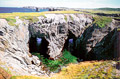
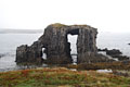
| NEWFOUNDLAND: Tickle Cove Arch.
Tickle Cove is a small community on the north coast of the Bonavista Peninsula. There are signs to the arch. The arch has a span of about 30 feet and a height of 25 feet. Photo by Ray Millar. NABSQNO 22U 316446 5384162. |
|
| NEWFOUNDLAND: Arch Rock. Arch Rock at Little Catalina on the Bonavista Peninsula is actually a triple sea arch. Two of the arches face towards land while the other is on the side of the formation. To get to Arch Rock, get on the road to Little Catalina. After about 1/4 mile, you will come to Eddy's Gas Bar. Park here and across the street you will find a sign marking the trail to Arch Rock. Photo by Robert O'Connell. NABSQNO 22U 0349019 5377898. |
|
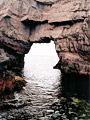
| NEWFOUNDLAND: Bell Island Arch. Bell Island is located in Conception Bay just a little to the north of St. John's. To find the arch, take the ferry to Bell Island and follow the signs to the lighthouse. The rock formation containing the arch is right near the lighthouse. From this vantage point, it is impossible to see completely through the arch but the light reflecting on the water beneath the arch makes it clear that the arch goes all the way through the rock. Photo by Robert O'Connell. |
|
| NEWFOUNDLAND: Berry Head Arch is located along the East Coast Trail to the south of St. John's. To get to the arch, find the East Coast Trail trailhead at Port Kirwan. From here, it is about a 4.75-mile one way hike to the arch. The hike is moderate but extreme caution is required at points where the trail skirts the edge of some rather high cliffs. The East Coast Trail Association has some good maps. Map #16, the Spurwink Island Path, covers the trail to Berry Head Arch. Photo by Robert O'Connell. NABSQNO 22T 0355533 5206715. |
|
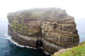
| NOVA SCOTIA: Big Arch (unofficial name) is in the vicinity of Cape Chignecto Provincial Park and is best accessed and viewed by sea kayak. A good way to get here is through NovaShores Adventures run by Else Marie and Werner Ostermann. If you tell them that you are interested in visiting some sea arches, they will arrange a professional and very enjoyable kayak tour for you. Photo by Robert O'Connell. |
|
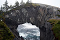
| NOVA SCOTIA: Double Arch (unofficial name) is in the vicinity of Cape Chignecto Provincial Park and is best accessed and viewed by sea kayak. A good way to get here is through NovaShores Adventures run by Else Marie and Werner Ostermann. If you tell them that you are interested in visiting some sea arches, they will arrange a professional and very enjoyable kayak tour for you. Photo by Robert O'Connell. |
|
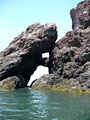
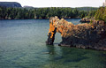
| NOVA SCOTIA: Long Arch (unofficial name) is in the vicinity of Cape Chignecto Provincial Park and is best accessed and viewed by sea kayak. A good way to get here is through NovaShores Adventures run by Else Marie and Werner Ostermann. If you tell them that you are interested in visiting some sea arches, they will arrange a professional and very enjoyable kayak tour for you. Although this arch has a span of only a few feet and a height of maybe ten feet, the distance through the opening is about 40 feet. A person can easily walk through it, and there are two other arches inside this arch. Photo by Robert O'Connell. |
|
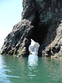
| ONTARIO: Sea Lion Rock is located in Sleeping Giant Provincial Park. From the Kabeyun Trailhead hike about a mile to the arch. The arch is on the shoreline of Lake Superior. It has an estimated span of 10 feet and estimated height of 12 feet. Photo by Kenneth Barker. |
|
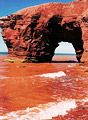
| PRINCE EDWARD ISLAND: Seal Point Arch. The rocks and sand are an incredibly rich red color.
Seal Point is located on the North Cape Coastal Drive between Howards Cove and Cape Wolfe. The arch can be seen to the south from the harbor at Howards Cove. To reach it drive back towards Cape Wolfe and watch out for a road off to the right. This will take you to a beach. There is a small arch to the right close to the access to the road. From the other side of this arch Seal Point Arch can be seen to the south. The arch has a span of about 20 feet and a height of about 15 feet. Photo by Ray Millar. |
|
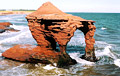
| PRINCE EDWARD ISLAND: Thunder Cove Arch.
This is all that is left of a 40-foot arch. The remaining spectacular sea stack has two openings. The arch is located at Thunder Cove near the small village of Darnley on the Blue Heron Coastal Drive. From Darnley drive towards the sea and take Thunder Cove Road. Park at the beach and walk along the cliff line to the left (west). In the distance there is a fence with a "no trespassing" sign. The arch is just before this is reached. If you walk the beach there is a small double sea arch in the first small headland. There is also a small arch at the east end of the cove.
The larger opening has a span of about 15 feet and a height of about 18 feet. Photo by Ray Millar. NABSQNO 20 T 450475 5156935. |
|
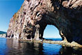
| QUEBEC: Percé Rock (pronounced "Percy"), with an opening approximately 50 feet high and 60 feet wide, stands at the eastern tip of Quebec's Gaspé Peninsula — a final sentry at the end of the Appalachian Mountain range. For four hours or so at low tide, Percé Rock can be reached on foot via a wide spit that connects it with the mainland. Sea kayaking is popular here, and at high tide you may paddle right through the arch. For more information, see the article by Rick Bolger in the April 2000 issue of SPAN, which is reprinted on his web page. Photo by Rick Bolger. |
|
| SASKATCHEWAN: Roche Percee is a small arch on provincial government land. There is a signed turnoff off Provincial Highway 39 about 7 miles east of Estevan. The arch (and another even smaller one) are about 3 miles down the paved road from the turnoff. Photo by Larry Fogleman. |
|
Go to next Gallery feature
- Chad Tibesti Portfolio
Return to International Gallery