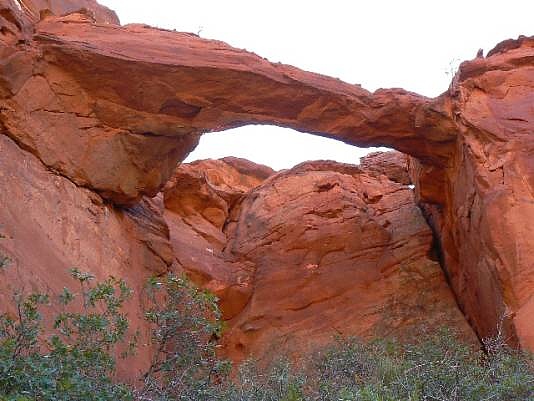
 From Hwy 89A turn north on road 1065 (the House Rock
Valley Road) for about 5.5 miles. Turn east onto a dirt road,
then immediately turn to the SE and drive as far as you dare (the
road ends in about a mile from road 1065). Look high on the
wall to see the arch. Hike north, climbing up a series of
sandstone cliffs, and then east to get beneath the arch. Total
hiking distance is about two miles, one way, and involves 500 ft.
of elevation change. UTM 12S 4-6016E 4073924N.
From Hwy 89A turn north on road 1065 (the House Rock
Valley Road) for about 5.5 miles. Turn east onto a dirt road,
then immediately turn to the SE and drive as far as you dare (the
road ends in about a mile from road 1065). Look high on the
wall to see the arch. Hike north, climbing up a series of
sandstone cliffs, and then east to get beneath the arch. Total
hiking distance is about two miles, one way, and involves 500 ft.
of elevation change. UTM 12S 4-6016E 4073924N.
|
| Photo and Directions by Rob Jones Trip Report |

|
Natural Arch and Bridge Society Home Page |
|
About Bob |
|
Return to Bob's Arches Home Page |
|
Return to Arizona Arches |