Algerian Tassili du Hoggar Adventure
by Guilain Debossens
|
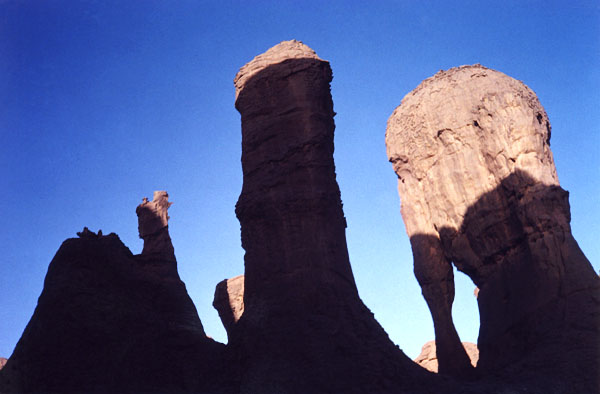
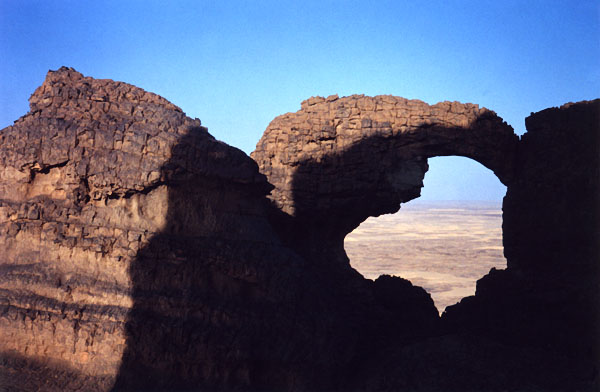
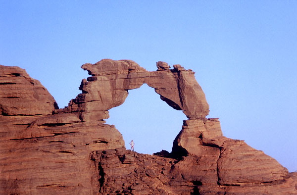
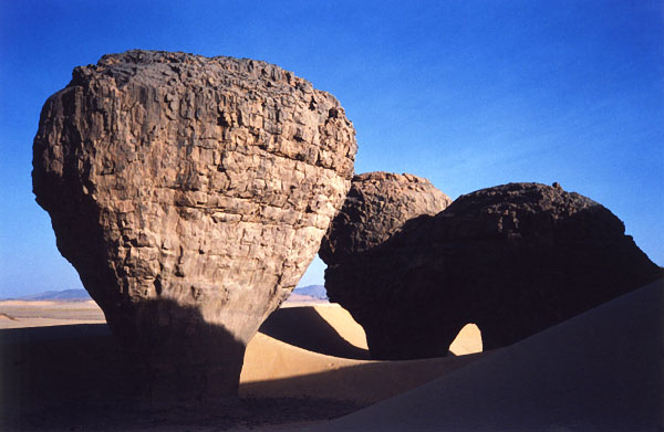
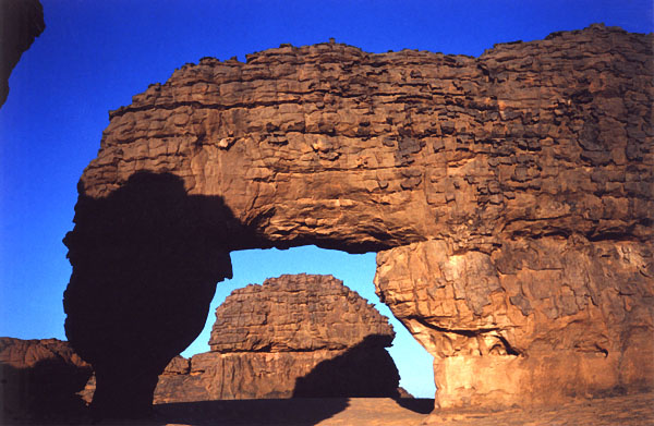
[Note: The information on this page is in the process of being moved to the new Ahaggar National Park section of this website. Once this process is completed, this page will be removed.] For my tenth visit to the southeastern Algerian Sahara Desert, I planned two different trips with my long time friend Daniel Putelat. The first trip was to visit for the first time the Tssili-n-Ahaggar (best known by the French name "Tassili du Hoggar"). This vast area is located 250 to 300 km southeast of the city of Tamanrasset, the capital city of the "grand south" of Algeria, located 2,000 km south of Algiers. The remote area of Tassili du Hoggar is reachable by a long six hours of four-wheel driving on a desert plain across oueds (washes) and rocky hills. It is formed by several ranges and plateaus including "El Ghessour," "In-Meskor" and "Tin-Eggoleh". In Tamanrasset we arranged directly with O.N.A.T. agency (National Algerian Agency of Tourism) for a seven-day round trip tour. We paid 7,000 dinars per day for two persons (about $90 U.S.) included Toyota 4WD, driver-guide and gas (we had our own food). On day one, the first objective was to visit the site of El-Ghessour, where we arrived near 3:00 p.m. It was very rainy two weeks before we visited the region, so the gueltas were full of water and many puddles were present in the rock surface. I had never seen the Sahara Desert with so much water! However, it is still ephemeral and the oued was already stagnant with cracked mud. The abundance of water was also responsible for a cloud of locusts on the desert plain. After getting trapped in deep blow sand (called "fech-fech"), we entered the El-Ghessour site via a sign-posted canyon. El-Ghessour is a mesa with a myriad of pinnacles and eroded buttes. Just above the canyon entrance we found several nice natural arches (on the south side) in a strange and intriguing landform of rock sculptures. Most of them were propped-type natural arches (an example is ALG-283). After a night sleeping in the open under a vault of stars, we explored this sandstone labyrinth more extensively before leaving in mid-afternoon for the second area we had planned to visit. To get there, we drove south for two hours to the site of Tin- Akacheker (The Castles). Most of the brochures report this site as the gem of Tassili du Hoggar, and it is true! Numerous spires emerge on top of the big sand dunes. The whole scene is spectacular. We climbed sand dune by sand dune behind the site to reach the the crest. The face of the main sand dune was over 60 meters in height and was too difficult to climb in the 35 degree Celsius desert heat (95F). However, we found another way around to get on the top, where we walked along the crest to a great vista of the surrounding desert. We were surprised to find a beautiful natural arch (ALG-284) hidden behind some rock masses overhanging the desert plain. The next night was very warm for that time of year (22 October). We woke up before sunrise to get an early start to visit a wonderful abandoned-type arch we saw in the distance the day before as we approached the Tin-Akacheker site by jeep. We hiked with the help of a headlamp to try to find the location. We found the distance from our bivouac site to be shorter than we had estimated and arrived before sunrise. The arch (ALG-285) is located at 32Q 235088E 2394722N, and we estimate the height to be about 12 meters. That's me inside for scale! The arch we had visited the day before (ALG-284) is actually close by, but perched inaccessibly on the rock masses above. Some other good arches are nearby as well. After taking pictures, we visited the south part of the area where our steps led us by chance to a pretty arch of 8.6 meters span (ALG-286) at 32Q 235690E 2393128N. These arches are probably not alone in this fantastic landscape of The Castles, but more time would be needed to explore, and other areas still awaited us on this trip.
The Tagrera area was the next stop, not too distant. We entered this location via "La Grande Dune," a wide sand dune overlooking the plain of the Oued Tagrera. This desert plain is scattered with innumerable rock masses and spires. The best known is the rock called La Chambre ("The Bedroom," ALG-287) in the northeast section of the plain. The half-circular rock contains a small natural arch (3.9 by 2.4 meters) at 32Q 237882E 2384988N. It is very photogenic due to the close proximity of little sand dunes and a mushroom rock. We used La Chambre for an appropriate bivouac for the night.
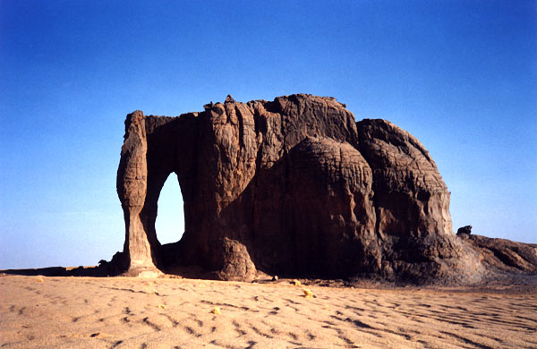
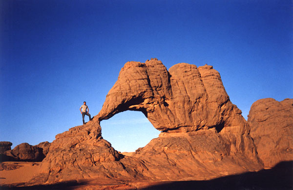
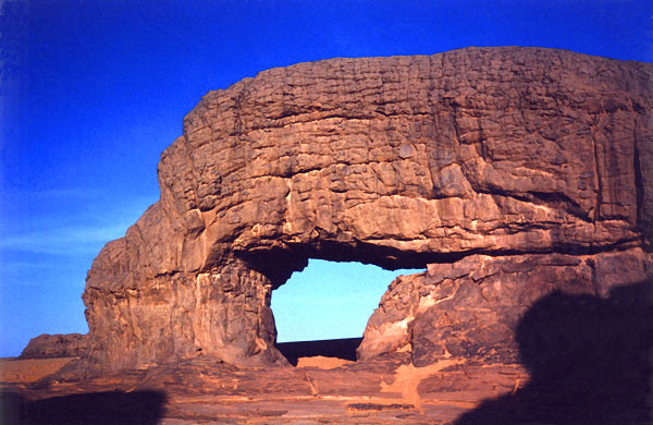
The next morning we took a 30-minute drive due east to Buddha's Valley ("Taguelman Semed" in the Tamahaq dialect). This site is visible from The Bedroom with binoculars. It is a small side canyon with a row of rocks which look like the Buddha's profile. Two interesting arches guard the valley entrance: an elephant rock (ALG-288) at 32Q 244137E 2379562N with an estimated eight-meter height, and a strange monolith nearby with a natural opening on the top (ALG-289). I think we can classify this unusual feature as a caprock-type natural arch. After a morning hike around the area before the big heat of the day (our usual pattern), we left the site for the next destination.
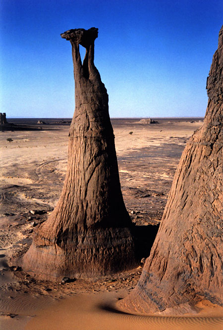
We drove northeast at full throttle on a sandy plain in a large "corridor" marked out with old oil drums located on each side of the tracks every half kilometer. These are the official tracks to In-Azaoua, which leads to the Niger border. It is only 80 kilometers from where we were to In-Azaoua and the Niger border, and this is certainly why we passed three jeeps of the Algerian army patrolling the area. After receiving a cordial check by the army, we covered a distance of 100 kilometers before arriving in sight of the Tahaggart site. We left "the corridor" and approached the site slowly because of numerous outcropping rocks which encircle the magnificent hills. The Tahaggart site can be described as huge sand dunes edged by fairy castles as if from a Walt Disney movie. It is flagrant natural splendor. A great arch about 10 meters in height stands at 32Q 307231E 2418494N (ALG-290). We bivouacked close by and the next morning we had a memorable sunrise on the arch. After a loop hike in this enchanted area, we took again the desert 4WD tracks to a new area. On the way we followed the big oued of Tin-Tarabine, which flows from the Hoggar mountains. We stopped on the way to visit a wide flat rock in the middle of the dry wash. The rock was engraved with dozens of figures (hippo, elephant, rhino, etc.).
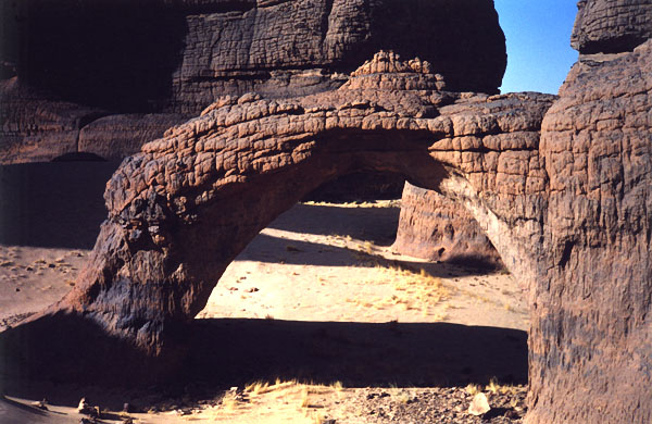
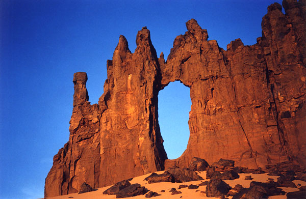
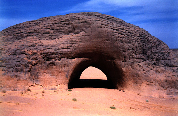
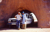
Near midday, we arrived at the site of Youf Ehakit (which means "better than tent" in the Tamahaq dialect). Matali, our driver-guide, who by now understood our interest in natural rock openings, guided us on a 45 minute side-trip to a seldom-seen natural arch called locally "Le Tunnel" (ALG-291). It is as perfectly shaped a tunnel as is a man-made one. It is five meters in height, has a 2.6 meter span, and is 10.5 meters deep. It is located at 32Q 275282E 2448817N. We used the tunnel to park the Toyota in the shade and had lunch inside.
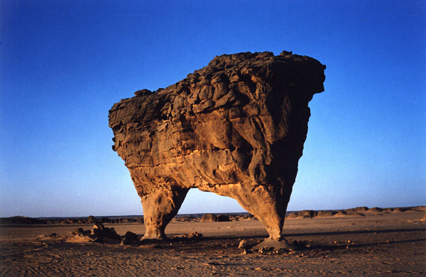
On the way back to the Youf Ehakit main area we passed by an incredible "bipod" arch (ALG-292) at 32Q 270429E 2434359N. I had a photo of this feature with me from a magazine to show Matali. He knew the arch location and promised to show it to me. The arch has a 5.6 meter span and a height of 1.9 meters. The thin leg is only 15 centimeters thick! Another small but nice arch is very close by (4.6 by 3.2 meters, ALG-293).
Five minutes from there, we stopped on the top of a big sand dune overlooking the oued of Tin-Tarabine, here full of acacia trees. We climbed down the dune with the Toyota and crossed the oued where the site of Youf Ehakit is signposted. Some distance from there another surprise awaited us! Two beautiful natural arches side by side provided the final bright cheer of the day. The main one is a nice elephant-shaped rock of 7.6 meters span at 32Q 267983E 2436027N (ALG-294). The second has a height of 4.3 meters (ALG-295). We bivouacked on the dune top which looks down upon the arches. Next morning we explored this great landscape on foot but we found few other openings.
On the last day of travel, we went back to Tamanrasset with the same driving time as the first day. The following day we took a 50-minute flight across the Hoggar mountains, which dropped us in Djanet where the Zeriba team was waiting for us for further adventures in Tassili- n-Ajjer [see Tassili National Park]. |
Next SPAN feature - April 2003 Article - Origin of Aloba Arch