Monument Valley, Arizona
A special portfolio by David Brandt-Erichsen and Jay H. Wilbur
Monument Valley Portfolio | Central Monument Valley | Mystery Valley | Hunt's Mesa | Eastern Monument Valley
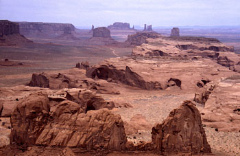
Monument Valley is most famous for its spectacular sandstone buttes and mesas, but it also contains numerous natural arches, including several of world-class beauty. The 17-mile self-drive scenic road through the valley does not include any of the natural arches. To see the arches within Monument Valley Navajo Tribal Park you must take a commercial tour or acquire a Navajo guide. Tour operators we've used in Monument Valley who know the out-of-the-way arches are Totem Pole Tours at (435) 727-3313 and Bill Crawley Tours. The arches are clustered in four different areas, each with its own Portfolio page. In addition, there are a couple of isolated arches that are included on this page. Unlike other sections of the NABS Gallery which only present a few selected arches in each area, this section provides a comprehensive listing of Monument Valley arches, including ones of lesser significance. The four other Portfolio pages are as follows: 1. Central Monument Valley. The area south of the 17-mile scenic drive and just south of Thunderbird Mesa contains a cluster of nice arches in close proximity. Many of these are seen in a standard commercial tour of Monument Valley. It takes a half-day to visit these arches. 2. Mystery Valley. This area southwest of central Monument Valley also contains several arches, but only a few of these are normally included in the commercial tours of Mystery Valley. It takes a half-day to visit all of these arches. 3. Hunt's Mesa Area. The canyons on the south edge of Hunt's Mesa contain some very large and very spectacular arches. These arches are very remote, require difficult 4-wheel drive approaches, and are seldom visited. It would take two days to visit all of these arches. Specially arranged tours would be needed. 4. Eastern Monument Valley. There is a string of several natural arches running north to south in the far eastern part of the Park, and shown on the Rooster Rock topo quadrangle. These are remote and seldom seen. It would take a full day to visit these arches. A specially arranged tour would be needed. The isolated arches that are not in the above clusters are illustrated below. For larger images and map locations, click on the thumbnail images on the right. |
| SKELETON ARCH is pictured in the Stan Jones Gallery (use the BACK button to return to this page). This is large pothole arch eroded in DeChelly sandstone. It is isolated from other Monument Valley arches and is located east of the central valley attractions. It is remote and seldom visited, but is a particularly spectacular arch. This arch is within the borders of Monument Valley Navajo Tribal Park and a Navajo guide is required for any visitation. |
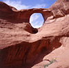 |
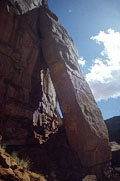
| OLLA HOUSE NATURAL ARCH. This arch is close to Olla House, an extensive and well preserved Anasazi cliff dwelling. It is a cave natural arch with two openings eroded through DeChelly sandstone. The larger opening has a span of about 25 feet. Although this arch is likely not within the borders of Monument Valley Navajo Tribal Park, it is within the Navajo Nation and this area is especially sensitive. Although a Navajo guide is required for any visitation, many guides will not take you because of the proximity to Olla House. Try to find a guide in Kayenta who is related to the family that lives nearby. |
 |
Two features that are not natural arches: |
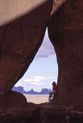 |
This feature has been made famous by a number of photographers who have used it to frame a vista of Monument Valley. Some photographers have referred to this feature as "Teardrop Arch," while others have labeled it "Sheepherders Arch." However, is not a natural arch but is rather an enlarged vertical crack. It is located in the cliffs southeast of Gouldings, Utah, across US Highway 163 from Monument Valley (MAP). Because it is in the Navajo Nation, the services of a guide should be used to visit it. [DBE photo.] |
 |
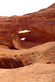
This feature is shown on the Mitten Buttes topographic map as "Natural Arch" at UTM coordinates 12S 585017E 4084888N (WGS84). It was formed by a slab of rock sloughing off a cliff and sliding into a position that created an opening. It therefore does not conform with the definition of a natural arch. [JHW photo.] |
Monument Valley Portfolio | Central Monument Valley | Mystery Valley | Hunt's Mesa | Eastern Monument Valley