Natural Arches of Grand Canyon
A Special Portfolio
Relatively little is known about the many natural arches in Grand Canyon, for two reasons: (1) most of them are extremely difficult to get to, often requiring multi-day backpacks over rough and trailless terrain, and (2) many of them, while spectacular to visit, just are not photogenic. The most thorough listing of Grand Canyon arches that we know of is the article "Spans of the Grand Canyon" by Bob Moore (SPAN, April, 1996). It lists 65 arches.
We have found very few photographs of natural arches within Grand Canyon. If you have any photos of arches not represented here, please let us add them to this portfolio.
Click on the thumbnail images below for full-size photos and map locations.
| KOLB NATURAL BRIDGE is the largest span in the Grand Canyon. It is a waterfall natural bridge located in the Redwall Limestone below Mt. Hayden and Point Imperial. The Hiking Logs of J. Harvey Butchart (Northern Arizona University Special Collections, 1989) reports a span of 147 feet. The span was discovered from the air by Arizona Senator Barry Goldwater in 1951, who later reached it from the ground. The extremely arduous trek to this arch has limited visitation to very few persons. A description of the trip along with this and other photos of the arch appeared in Arizona Highways, April, 2005. Photo (copyright retained) by Elias Butler. |
|
| ALAMO WINDOW is located on top of the Redwall on the rim of Fern Glen Canyon. It is not visible from the Grand Canyon rim or from the river, but is visible from a certain spot at the bottom of Fern Glen Canyon "if you know just where to stand". The top can be accessed by backpacking down the Tuckup Trail and going cross-country to the arch. It has an 80-foot span that is spectacular to witness but which nearly disappears in photos because the vantage point does not provide sky through the opening. Photo by Bob Moore. |
|
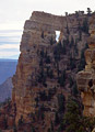
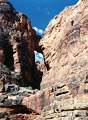
| ANGELS WINDOW is the only easily accessible arch in Grand Canyon. You can drive the paved Cape Royal Road on the North Rim and park at the viewpoint and walk out over the top of the arch. Photo by Jay H. Wilbur. |
|
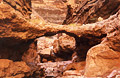
| BOYSAG POINT ARCH is one of those few Grand Canyon arches that does not require a "killer" backpack. It is still very remote, however, and requires tricky 4WD navigation after leaving the Mt. Trumbull Road, followed by a cross-country hike to Boysag Point. This arch in Kaibab Limestone has a span of 15 feet and a height of 6 feet. It is on a narrow neck of land which leads out to the point. Photo by Bob Moore. |
|
| BRIDGE OF SIGHS is one of the few Grand Canyon arches that is visible from the river (at mile 35.6, on the right). It is located in Redwall Limestone and has a span of 15 feet and a height of 30 feet. Photo by Bob Wenrick. |
|
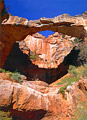
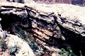
| CONGLOMERATE ARCH is a waterfall natural bridge that spans Tuckup Canyon below Dome Pocket. It has an estimated span of 24 feet and height of 12 feet. As the name suggests, it is composed of conglomerate, in this case rocks cemented together with travertine, making for a relatively fragile structure. Photo by Bob Moore. |
|
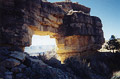
| JICARILLA BRIDGE is located directly on the South Rim of Grand Canyon, in Kaibab Limestone, just west of Jicarilla Point. It is another of the few Grand Canyon arches that does not require a "killer backpack" to reach. It does require navigating some confusing 4WD roads and a cross-country hike. It has a span of about 40 feet. Photo by Larry Fogleman. |
|
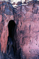
| KEYHOLE NATURAL BRIDGE is located in Redwall Limestone in a tributary of 140-Mile Canyon. It has an approximate span of 40 feet and height of 100 feet. First-hand reports indicate that the Keyhole is "breathtaking" to see in person, but you certainly cannot tell this from the photos! This is a perfect example of how Grand Canyon arches can be spectacular to visit but not be photogenic. On average, about one person per year visits this lonely spot. Photo by Bob Moore. |
|
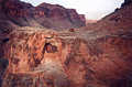
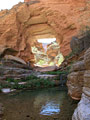
| ROYAL ARCH is a natural bridge spanning a perennial creek above Elves Chasm (although not accessible from there). It has a span of 60 feet. Reaching it involves a very difficult multi-day backpack from South Bass and Tonto Trails. The route is shown on the National Geographic Trails Illustrated map of Grand Canyon. Photo by Paul Neiman (see photos and slideshow of his trip here). For scale, notice the group of three people standing just to the left of the opening. |
|
Go to next Gallery feature
- Hell Hole Canyon
Return to Arizona Gallery