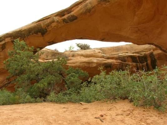
 This large arch is north of Moab on the west side of US 191.
It has a span of 75 ft.. Driving north on US 191, note your
mileage at the intersection of Utah 313 (the road to Dead Horse
Point and Island in the Sky). Continue north on US191 for
5/8 of a mile and turn diagonally left onto a gravel road (this
is Jeep Trail No. 9 on Trails Illustrated/National Geographic Map
Moab North Map No. 500). Continue on this trail for 1 1/8 miles
keeping left at a junction for about an eighth of a mile and turn
right (north) at a second junction. Continue north for about 5/8
mile and turn left (this is still Jeep Trail No. 9) for about a quarter
mile where the road turns south. Follow the trail south, keeping
left at 3 junctions. Follow the trail around the south end of Corral Canyon, and follow a cliff for about a half mile and turn right aout 3/8 of a mile to the arch. There are many side trails which make it confusing to follow directions. One help in staying on-route is to follow the “7 Mile Rim Trail “ signs. Near the arch is a sign painted on the slickrock that simply says “arch”. The final part of the trail to the base of the arch is intimidating, but is negotiable by a properly equipped off-road vehicle. GPS Latitude and Longitude are
38deg. 40.570’N, 109deg. 42.4221’W, Altitude, 5196 ft.
This large arch is north of Moab on the west side of US 191.
It has a span of 75 ft.. Driving north on US 191, note your
mileage at the intersection of Utah 313 (the road to Dead Horse
Point and Island in the Sky). Continue north on US191 for
5/8 of a mile and turn diagonally left onto a gravel road (this
is Jeep Trail No. 9 on Trails Illustrated/National Geographic Map
Moab North Map No. 500). Continue on this trail for 1 1/8 miles
keeping left at a junction for about an eighth of a mile and turn
right (north) at a second junction. Continue north for about 5/8
mile and turn left (this is still Jeep Trail No. 9) for about a quarter
mile where the road turns south. Follow the trail south, keeping
left at 3 junctions. Follow the trail around the south end of Corral Canyon, and follow a cliff for about a half mile and turn right aout 3/8 of a mile to the arch. There are many side trails which make it confusing to follow directions. One help in staying on-route is to follow the “7 Mile Rim Trail “ signs. Near the arch is a sign painted on the slickrock that simply says “arch”. The final part of the trail to the base of the arch is intimidating, but is negotiable by a properly equipped off-road vehicle. GPS Latitude and Longitude are
38deg. 40.570’N, 109deg. 42.4221’W, Altitude, 5196 ft.
|
