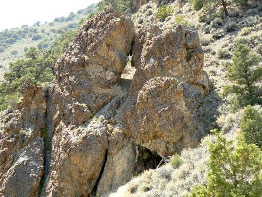
 The name for this Nevada arch was derived from its location
and what apears to be a rock shelter below the arch. Drive
about 65 miles north of Tonopah on Nevada Hwy 376.
Take Forest Road 080 west to the South Twin Rivers Trailhead
which is about 3 miles off the highway. Approximate
coordinates for the TH are: UTM 11 S 479150N 4304413W
(WGS84). Hike up the South Twin River Trail that goes steeply
up the side hill east of where South Twin emerges from the
narrow canyon for approximately 5.5 miles. Do not begin by
hiking up the river. You will be a few hundred yards NE of the
junction of the South Twin and North Twin River Trails.
(Caution: the North Twin River Trail exists mostly on the map,
not the ground) The arch is NW of and near the trail at about
elev. 7900 ft. The approximate gps coordinates for the arch
are UTM 11 S 474660N 4300431W (WGS84).
There is an old water wheel and ore crusher about 3 miles
up the South Twin River trail, just downstream of the confluence
of South Fork Twin and South Twin River. The wheel still
turns! The wheel is approximately at UTM 11 S 476524N
4301252W (WGS 84) and 7300 ft. elev.
The name for this Nevada arch was derived from its location
and what apears to be a rock shelter below the arch. Drive
about 65 miles north of Tonopah on Nevada Hwy 376.
Take Forest Road 080 west to the South Twin Rivers Trailhead
which is about 3 miles off the highway. Approximate
coordinates for the TH are: UTM 11 S 479150N 4304413W
(WGS84). Hike up the South Twin River Trail that goes steeply
up the side hill east of where South Twin emerges from the
narrow canyon for approximately 5.5 miles. Do not begin by
hiking up the river. You will be a few hundred yards NE of the
junction of the South Twin and North Twin River Trails.
(Caution: the North Twin River Trail exists mostly on the map,
not the ground) The arch is NW of and near the trail at about
elev. 7900 ft. The approximate gps coordinates for the arch
are UTM 11 S 474660N 4300431W (WGS84).
There is an old water wheel and ore crusher about 3 miles
up the South Twin River trail, just downstream of the confluence
of South Fork Twin and South Twin River. The wheel still
turns! The wheel is approximately at UTM 11 S 476524N
4301252W (WGS 84) and 7300 ft. elev.
Photo and directions by Rob Jones
|
|
