 This span is located in the Painted Desert part of the Park north
of Interstate 40 (Exit No. 411).
This span is located in the Painted Desert part of the Park north
of Interstate 40 (Exit No. 411).
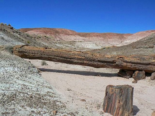
Onyx N.B had for some time been thought to have collapsed. What appeared to be a collapsed span near the coordinates published on Geological Survey maps and elsewhere led some to assume Onyx N.B. had fallen. It appears that these coordinates were incorrect, leading to a false conclusion. Rob successfully located the span and recorded accurate UTM coordinates. Park at the Painted Desert Inn (now a Visitors Center). The Black Forest Route (not a trail) starts on the west side of the Inn. Before starting off the rim, look north and observe the wide drainage of Lithodendron Wash. The wash makes a sweeping "S" turn, the lower end of which is about 2 miles from this vantage point. In the middle of the "S" turn, spot a purplish clay hill with a sprinkling of white rocks forming its top. The span is in the left sweep of the "S" where the wash turns north. Walk down the switchbacks from the Inn and out toward Lithodendron Wash. Head for that low butte you spotted from the top. Set your GPS and, at the top left of the "S" turn of the wash (where it turns east) hike northwest up the widest of the low drainages; then right at the next turn. You will soon come to a 10 ft. overhang above you. The span is just above the pour-off at these (correct) coordinates: UTM 12S 610071E 3885859N WGS84. Note that UTM 12S 610358E 3886039N which are listed as the correct coordinates in Garmin GPS mapping software and on the USGS Map are not correct; and are possibly the origin of reports that the N.B. had fallen. Photo by Rob Jones Trip Report |
