|
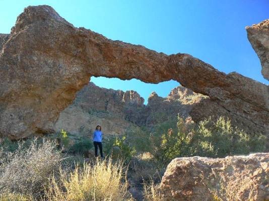
This arch is in the Superstition Mountains (home of the famous Lost Dutchman Mine)
east of Phoenix, Arizona. From Apache Junction, travel S.E. on Rt. 60 to Florence Junction and continue east on Rt. 60 to mile post 214.1. Turn N.E. onto paved Queen Valley Rd. and drive 1.7 miles to Hewitt Station Rd. Turn right onto this dirt road and continue for 3.0 miles. Watch for an old Forest Service sign on the right side which directs you to Woodbury/ Superstition trailhead.. Turn left on Forest Service Rd. 172 and cross a wide drainage (usually dry). At 1.6 miles, pass junction of Forest Rd 252, and continue on FR 172 for another 2.3 miles for a view of the arch. Numerous ORV trails confuse the area, yet stay on the main route. Look for the arch about 200 ft. above you on the left. Approximate GPS coordinates for the arch are: (WGS 84) UTM 12S 0479595E 3689663N. Elevation 2580 ft.
Photo by
|
