 Turn north from US 89A onto House Rock Rd (BLM Road 1065)
(dirt) for about 8 miles. About a quarter mile north of the West
Branch Pueblo turnoff, the Arch can be seen off to the east. As you
drive a little further north from this turnoff, you'll notice a totem- pole
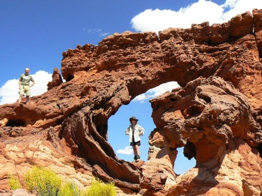
spire on the south end of a slickrock island. The Arch is on the
island with the totem pole, about a mile from the road. Park opposite
the Arch- there's a wide spot off the west side of the road. This will
be the trailhead, even though there is no real trail to the Arch. The
trailhead is at UTM 12S 405173E 4079264N (WGS84). Wade the
sage to the Arch located at UTM 12S406435E 4079362N. To see
the GPS track for this hike of about 2.5 miles round trip, go to:
The Wilderness Vagabond -
Double Barrel.
Turn north from US 89A onto House Rock Rd (BLM Road 1065)
(dirt) for about 8 miles. About a quarter mile north of the West
Branch Pueblo turnoff, the Arch can be seen off to the east. As you
drive a little further north from this turnoff, you'll notice a totem- pole
spire on the south end of a slickrock island. The Arch is on the
island with the totem pole, about a mile from the road. Park opposite
the Arch- there's a wide spot off the west side of the road. This will
be the trailhead, even though there is no real trail to the Arch. The
trailhead is at UTM 12S 405173E 4079264N (WGS84). Wade the
sage to the Arch located at UTM 12S406435E 4079362N. To see
the GPS track for this hike of about 2.5 miles round trip, go to:
The Wilderness Vagabond -
Double Barrel.
|

|
Natural Arch and Bridge Society Home Page |
|
About Bob |
|
Return to Bob's Arches Home Page |
|
Return to Arizona Arches |