 From the “Y” (junction of highways 89A and 179) in Sedona, Arizona
Drive 3.1 miles SW on 89A (toward the town of Cottonwood) to Dry
Creek Road. Turn right onto Dry Creek Rd. and drive 2 miles, then
turn right onto the dirt FR152, signed for Vultee Arch. After about 1.3
miles, you will see a sign for the Devil’s NB parking area just off to the
right of this FR road. Start hiking on a closed road, which turns into a
well-marked trail. It is a little over one mile hiking (one way) to the NB.
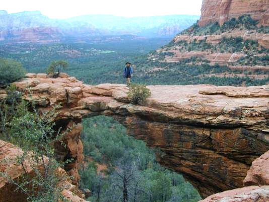
One can hike below the NB or on a trail to the top. The span of the
sandstone NB is reported to be just over 45 ft. It has a thickness of 5 ft.
and a height of 54 ft. It is just inside the border of the Red Rock Sacred
Mountain Wilderness. The UTM coordinates for the NB are approximately
12S 426210 3861989 WGS84.
From the “Y” (junction of highways 89A and 179) in Sedona, Arizona
Drive 3.1 miles SW on 89A (toward the town of Cottonwood) to Dry
Creek Road. Turn right onto Dry Creek Rd. and drive 2 miles, then
turn right onto the dirt FR152, signed for Vultee Arch. After about 1.3
miles, you will see a sign for the Devil’s NB parking area just off to the
right of this FR road. Start hiking on a closed road, which turns into a
well-marked trail. It is a little over one mile hiking (one way) to the NB.
One can hike below the NB or on a trail to the top. The span of the
sandstone NB is reported to be just over 45 ft. It has a thickness of 5 ft.
and a height of 54 ft. It is just inside the border of the Red Rock Sacred
Mountain Wilderness. The UTM coordinates for the NB are approximately
12S 426210 3861989 WGS84.
|
