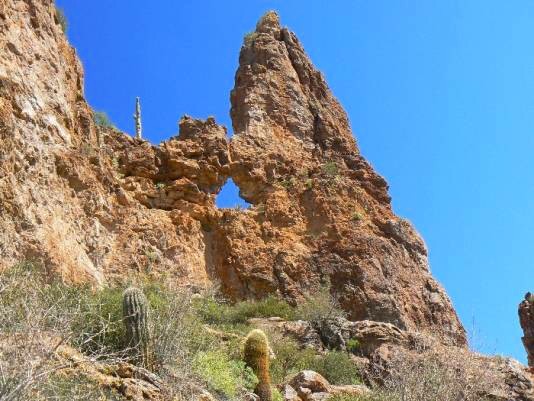
 This arch is located in the Superstition Mountains east of Phoenix.
From the intersection of AZ88 and US60 in Apache Junction, drive
SE on US60 for about 8 ½ miles to Peralta Rd (FR 77). Drive NE on
Peralta Rd. to the Peralta Trailhead. See Rob’s Trip Report Superstition Mountain
Backpack Click on the map. This map shows the routes and waypoints.
There is a maze of numbered trails in this area so it’s necessary to
obtain a good trail map of the area
This arch is located in the Superstition Mountains east of Phoenix.
From the intersection of AZ88 and US60 in Apache Junction, drive
SE on US60 for about 8 ½ miles to Peralta Rd (FR 77). Drive NE on
Peralta Rd. to the Peralta Trailhead. See Rob’s Trip Report Superstition Mountain
Backpack Click on the map. This map shows the routes and waypoints.
There is a maze of numbered trails in this area so it’s necessary to
obtain a good trail map of the area
From where the trail traveling down Whiskey Spring Canyon crosses LaBarge Creek, near the viewpoint for Laconic Dodo, qv, hike up LaBarge Canyon toward LaBarge Box for about 0.75 miles. Pyramid Peeper will be visible on the left (north) side of the trail at approximate coordinates of UTM 12S 472320E, 3699547N. |

|
Natural Arch and Bridge Society Home Page |
|
About Bob |
|
Return to Bob's Arches Home Page |
|
Return to Arizona Arches |