 From the Sedona Y round-abouts at the junction of Hwys 89A and 170,
continue on 89A for 3.1 miles to Dry Creek Rd. Turn right onto Dry Creek
and drive 2.9 miles to a stop sign. Turn right and drive 0.6 miles to the Long
Canyon Trailhead on your left.
From the Sedona Y round-abouts at the junction of Hwys 89A and 170,
continue on 89A for 3.1 miles to Dry Creek Rd. Turn right onto Dry Creek
and drive 2.9 miles to a stop sign. Turn right and drive 0.6 miles to the Long
Canyon Trailhead on your left.
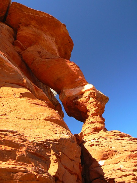
Hike 0.6 miles on the Long Canyon Trail ; and turn left off the trail just before reaching a fence. This is a well-used, but un-official trail to Mescal Mountain. Keep a lookout for a view of the arch - which looks like a log propped against the nose of the mesa to your left. This view point is near a side trail into a rounded alcove. Continue on the route to the mesa. Clamber up on the neck of the mesa and turn left. Walk up the use trail to the foot of the top wall of Mescal Mountain. There is a short frictioneer scramble to the top at UTM 12S 0423535E 3863424N (WGS 84). Don't scramble to the top, however, if you want a close view of tthe arch. Instead, continue along the base of the mesa top wall, about 30 ft. below the top, slipping carefully between brush and sandstone wall to the nose of the mesa. The arch is on the nose, just above you as you reach the next mesa neck at UTM 12S 0423666E 3863275N (WGS84). Photo and directions by Rob Jones |

|
Natural Arch and Bridge Society Home Page |
|
About Bob |
|
Return to Bob's Arches Home Page |
|
Return to Arizona Arches |