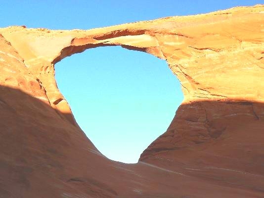
 This gorgeous and graceful arch is west of Chinle Arizona. At milepost 446.6 on Highway 191, turn west onto the road marked for the Chinle Hospital. This is Rt. 102-3 and it is 1.2 miles south of the main street in Chinle (Navajo Rt. 7) which goes to Canyon de Chelly N.M. Drive west 0.9 miles and turn left and skirt around the east side of the hospital. In 1.2 miles, the road joins a plethora of routes. Continue ahead and slightly to the left, passing the large municipal water tank on the left (south) side and climb the low mesa. Stay on this main road for 6 miles as it weaves along the mesa top. Park near a large metal power pole and two salmon-colored fins. The total distance from the Hwy 191 turnoff to the car park is 8.1 miles.
If you cross under the transmission line while driving, back- up about a half mile to the fins. From the fins, you should be able to see Hope Arch about 0.5 miles to the north, a narrow buttress attached to the mesa. The route to the arch is alongside the fins, under the transmission line, and through the sand to the edge of the mesa (travel not recommended-you are in the Navajo Nation). The UTM coordinates for the arch are approximately 12S 061784E 4007163N (WS84) at an elevation of about 5800 ft. The arch has a span of 65 ft. and a vertical opening height of 70 ft.
This gorgeous and graceful arch is west of Chinle Arizona. At milepost 446.6 on Highway 191, turn west onto the road marked for the Chinle Hospital. This is Rt. 102-3 and it is 1.2 miles south of the main street in Chinle (Navajo Rt. 7) which goes to Canyon de Chelly N.M. Drive west 0.9 miles and turn left and skirt around the east side of the hospital. In 1.2 miles, the road joins a plethora of routes. Continue ahead and slightly to the left, passing the large municipal water tank on the left (south) side and climb the low mesa. Stay on this main road for 6 miles as it weaves along the mesa top. Park near a large metal power pole and two salmon-colored fins. The total distance from the Hwy 191 turnoff to the car park is 8.1 miles.
If you cross under the transmission line while driving, back- up about a half mile to the fins. From the fins, you should be able to see Hope Arch about 0.5 miles to the north, a narrow buttress attached to the mesa. The route to the arch is alongside the fins, under the transmission line, and through the sand to the edge of the mesa (travel not recommended-you are in the Navajo Nation). The UTM coordinates for the arch are approximately 12S 061784E 4007163N (WS84) at an elevation of about 5800 ft. The arch has a span of 65 ft. and a vertical opening height of 70 ft.
|

|
Natural Arch and Bridge Society Home Page |
|
About Bob |
|
Return to Bob's Arches Home Page |
|
Return to Arizona Arches |